
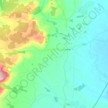
Carte topographique Ardagh
Carte interactive
Cliquez sur la carte pour afficher l’altitude.
À propos de cette carte
Nom : Carte topographique Ardagh, altitude, relief.
Altitude moyenne : 106 m
Altitude minimum : 38 m
Altitude maximum : 308 m
Autres cartes topographiques
Cliquez sur une carte pour visualiser sa topographie, son altitude et son relief.
Knockaderry
Ireland > The Municipal District of Newcastle West
Knockaderry, The Municipal District of Newcastle West, County Limerick, Munster, Ireland
Altitude moyenne : 64 m
Tarbet Bay
Ireland > The Municipal District of Newcastle West
Tarbet Bay, Glin, The Municipal District of Newcastle West, County Limerick, Munster, Ireland
Altitude moyenne : 9 m
Feohanagh
Ireland > The Municipal District of Newcastle West
Feohanagh, Broadford, The Municipal District of Newcastle West, County Limerick, Munster, Ireland
Altitude moyenne : 72 m
Feohanagh
Ireland > The Municipal District of Newcastle West
Feohanagh, Broadford, The Municipal District of Newcastle West, County Limerick, Munster, Ireland
Altitude moyenne : 71 m
Knockaunnagun
Ireland > The Municipal District of Newcastle West
Knockaunnagun, Glensharrold, The Municipal District of Newcastle West, County Limerick, Munster, Ireland
Altitude moyenne : 202 m
Ballintober
Ireland > The Municipal District of Newcastle West
Ballintober, The Municipal District of Newcastle West, County Limerick, Munster, Ireland
Altitude moyenne : 122 m