
Carte topographique Broeksterwâld
Carte interactive
Cliquez sur la carte pour afficher l’altitude.
À propos de cette carte
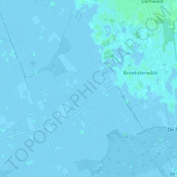
Nom : Carte topographique Broeksterwâld, altitude, relief.
Lieu : Broeksterwâld, Dantumadiel, Friesland, Niederlande (53.25829 5.94406 53.28289 6.01072)
Altitude moyenne : 0 m
Altitude minimum : -5 m
Altitude maximum : 5 m
Autres cartes topographiques
Cliquez sur une carte pour visualiser sa topographie, son altitude et son relief.
Feanwâlden
Niederlande > Friesland > Dantumadiel
Feanwâlden, Dantumadiel, Friesland, Niederlande
Altitude moyenne : 0 m
Sibrandahûs
Niederlande > Friesland > Dantumadiel
Sibrandahûs, Dantumadiel, Friesland, Niederlande
Altitude moyenne : 0 m
De Falom
Niederlande > Friesland > Dantumadiel
De Falom, Dantumadiel, Friesland, Niederlande
Altitude moyenne : 0 m
Readtsjerk
Niederlande > Friesland > Dantumadiel
Readtsjerk, Dantumadiel, Friesland, Niederlande
Altitude moyenne : 0 m