
Carte topographique Sulingen
Carte interactive
Cliquez sur la carte pour afficher l’altitude.
À propos de cette carte
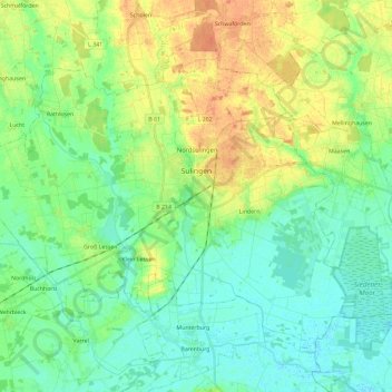
Nom : Carte topographique Sulingen, altitude, relief.
Lieu : Sulingen, Landkreis Diepholz, Lower Saxony, 27232, Germany (52.61733 8.65793 52.72997 8.89059)
Altitude moyenne : 44 m
Altitude minimum : 31 m
Altitude maximum : 65 m
Autres cartes topographiques
Cliquez sur une carte pour visualiser sa topographie, son altitude et son relief.
Barnstorf
Germany > Lower Saxony > Landkreis Diepholz
Barnstorf, Samtgemeinde Barnstorf, Landkreis Diepholz, Lower Saxony, Germany
Altitude moyenne : 38 m
Drebber
Germany > Lower Saxony > Landkreis Diepholz > Drebber
Drebber, Samtgemeinde Barnstorf, Landkreis Diepholz, Lower Saxony, 49457, Germany
Altitude moyenne : 38 m
Syke
Germany > Lower Saxony > Landkreis Diepholz
Syke, Landkreis Diepholz, Lower Saxony, 28857, Germany
Altitude moyenne : 33 m
Brockum
Germany > Lower Saxony > Landkreis Diepholz
Brockum, Samtgemeinde Altes Amt Lemförde, Landkreis Diepholz, Lower Saxony, Germany
Altitude moyenne : 47 m