
Carte topographique Marbella
Carte interactive
Cliquez sur la carte pour afficher l’altitude.
À propos de cette carte
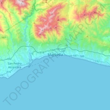
Nom : Carte topographique Marbella, altitude, relief.
Lieu : Marbella, Costa del Sol Occidental, Malaga, Andalusia, Spain (36.46001 -5.01467 36.55497 -4.73057)
Altitude moyenne : 216 m
Altitude minimum : -1 m
Altitude maximum : 1’319 m
There are five geomorphological units: the Sierra Blanca, the Sierra Blanca piedmont (foothills), the lower hill country, the plains and the coastal dunes. The Sierra Blanca is most centrally located in the province, looming over the old village. This mountain range has three peaks: La Concha, located further west at 1,215 m (3,986 feet) above sea level, Juanar Cross, located eastward (within the municipality of Ojen) at 1,178 m (3,865 feet) above sea level, and the highest, Mount Lastonar, located between the two at 1,270 m (4,170 feet). Marbella's topography is characterised by extensive coastal plains formed from eroded mountains. North of the plain, is an area of elevations from 100 and 400 m (330 and 1,300 feet), occupied by low hills, with foothills and steeper slopes of the mountains behind. The coast is generally low and has sandy beaches that are more extensive further east, between the fishing port and Cabopino. Despite the intense urbanisation of the coast, it still retains a natural area of dunes, the Artola Dunes (Dunas de Artola), at the eastern end of town.
Autres cartes topographiques
Cliquez sur une carte pour visualiser sa topographie, son altitude et son relief.
Casares
Spain > Andalusia > Costa del Sol Occidental
Casares, Costa del Sol Occidental, Malaga, Andalusia, Spain
Altitude moyenne : 224 m