
Carte topographique Mount Rushmore National Memorial
Carte interactive
Cliquez sur la carte pour afficher l’altitude.
À propos de cette carte
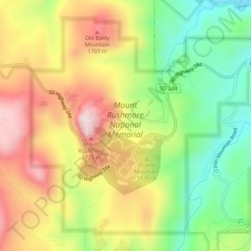
Nom : Carte topographique Mount Rushmore National Memorial, altitude, relief.
Altitude moyenne : 1’528 m
Altitude minimum : 1’343 m
Altitude maximum : 1’726 m
The Mount Rushmore National Memorial is a national memorial centered on a colossal sculpture carved into the granite face of Mount Rushmore (Lakota: Tȟuŋkášila Šákpe, or Six Grandfathers) in the Black Hills near Keystone, South Dakota, United States. Sculptor Gutzon Borglum designed the sculpture, called Shrine of Democracy, and oversaw the project's execution from 1927 to 1941 with the help of his son, Lincoln Borglum. The sculpture features the 60-foot-tall (18 m) heads of four United States presidents: George Washington, Thomas Jefferson, Theodore Roosevelt, and Abraham Lincoln, chosen to represent the nation's birth, growth, development and preservation, respectively. Mount Rushmore attracts more than two million visitors annually to the memorial park which covers 1,278 acres (2.00 sq mi; 5.17 km2). The mountain's elevation is 5,725 feet (1,745 m) above sea level.
Autres cartes topographiques
Cliquez sur une carte pour visualiser sa topographie, son altitude et son relief.
Rapid City
United States > South Dakota > Pennington County
Rapid City, Pennington County, South Dakota, United States
Altitude moyenne : 1’068 m
Black Hills
United States > South Dakota > Pennington County
Black Hills, Pennington County, South Dakota, United States
Altitude moyenne : 1’894 m
Colonial Pine Hills
United States > South Dakota > Pennington County
Colonial Pine Hills, Pennington County, South Dakota, United States
Altitude moyenne : 1’232 m
Thrall Mountain
United States > South Dakota > Pennington County
Thrall Mountain, Pennington County, South Dakota, United States
Altitude moyenne : 1’392 m
Scenic
United States > South Dakota > Pennington County
Scenic, Pennington County, South Dakota, 57780, United States
Altitude moyenne : 853 m
Horse Thief Lake
United States > South Dakota > Pennington County
Horse Thief Lake, Pennington County, South Dakota, United States
Altitude moyenne : 1’564 m
Silver City
United States > South Dakota > Pennington County
Silver City, Pennington County, South Dakota, United States
Altitude moyenne : 1’495 m
Copper Mountain
United States > South Dakota > Pennington County
Copper Mountain, West Pennington, Pennington County, South Dakota, United States
Altitude moyenne : 2’006 m
Wall
United States > South Dakota > Pennington County
Wall, Pennington County, South Dakota, 57790, United States
Altitude moyenne : 854 m
Box Elder
United States > South Dakota > Pennington County
Box Elder, Pennington County, South Dakota, United States
Altitude moyenne : 968 m
Hill City
United States > South Dakota > Pennington County
Hill City, Pennington County, South Dakota, United States
Altitude moyenne : 1’571 m
Warbonnet
United States > South Dakota > Pennington County > Warbonnet
Warbonnet, Pennington County, South Dakota, United States
Altitude moyenne : 966 m
Black Elk Peak
United States > South Dakota > Pennington County
Black Elk Peak, Pennington County, South Dakota, United States
Altitude moyenne : 1’923 m