
Carte topographique Cookstown
Carte interactive
Cliquez sur la carte pour afficher l’altitude.
À propos de cette carte
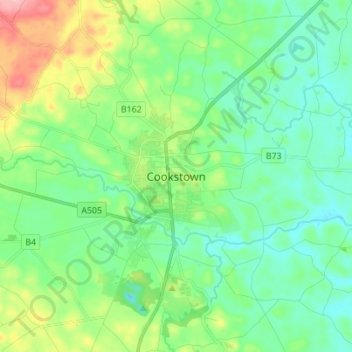
Nom : Carte topographique Cookstown, altitude, relief.
Altitude moyenne : 67 m
Altitude minimum : 27 m
Altitude maximum : 176 m
Autres cartes topographiques
Cliquez sur une carte pour visualiser sa topographie, son altitude et son relief.
Pomeroy
United Kingdom > Northern Ireland > County Tyrone
Pomeroy, County Tyrone, Northern Ireland, BT70 2RD, United Kingdom
Altitude moyenne : 169 m
Propect
United Kingdom > Northern Ireland > County Tyrone > Bready
Propect, Bready, County Tyrone, Ulster, Northern Ireland, BT82 0ED, United Kingdom
Altitude moyenne : 56 m
Dungannon
United Kingdom > Northern Ireland > County Tyrone > Dungannon
Dungannon, County Tyrone, Northern Ireland, BT71 7AA, United Kingdom
Altitude moyenne : 76 m