
Faire un don
Équipez-vous pour votre prochaine aventure :
En tant que Partenaire Amazon, ce site perçoit une commission sur les achats éligibles sans surcoût pour vous.
Carte topographique Whiteswan Lake
Cliquez sur la carte pour afficher l’altitude.
Faire un don
Équipez-vous pour votre prochaine aventure :
En tant que Partenaire Amazon, ce site perçoit une commission sur les achats éligibles sans surcoût pour vous.
À propos de cette carte
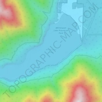
Nom : Carte topographique Whiteswan Lake, altitude, relief.
Altitude moyenne : 1’392 m
Altitude minimum : 1’131 m
Altitude maximum : 2’229 m
Faire un don
Équipez-vous pour votre prochaine aventure :
En tant que Partenaire Amazon, ce site perçoit une commission sur les achats éligibles sans surcoût pour vous.
Autres cartes topographiques
Cliquez sur une carte pour visualiser sa topographie, son altitude et son relief.
Windermere Lake
Canada > British Columbia > Regional District of East Kootenay > Area F (Columbia Lake/Windermere Lake) > Windermere
Altitude moyenne : 1’010 m
Shuswap
Canada > British Columbia > Regional District of East Kootenay > Area F (Columbia Lake/Windermere Lake)
Altitude moyenne : 926 m
Fairmont Hot Springs
Canada > British Columbia > Regional District of East Kootenay > Area F (Columbia Lake/Windermere Lake)
Altitude moyenne : 920 m
Whiteswan Lake Provincial Park
Canada > British Columbia > Regional District of East Kootenay > Area F (Columbia Lake/Windermere Lake)
Altitude moyenne : 1’667 m
Faire un don
Équipez-vous pour votre prochaine aventure :
En tant que Partenaire Amazon, ce site perçoit une commission sur les achats éligibles sans surcoût pour vous.
Mount Worthington
Canada > British Columbia > Regional District of East Kootenay > Area F (Columbia Lake/Windermere Lake)
Altitude moyenne : 2’421 m
Lockwood Peak
Canada > British Columbia > Regional District of East Kootenay > Area F (Columbia Lake/Windermere Lake)
Altitude moyenne : 2’225 m
Panorama Mountain Village
Canada > British Columbia > Regional District of East Kootenay > Area F (Columbia Lake/Windermere Lake)
Altitude moyenne : 1’412 m
Columbia Lake
Canada > British Columbia > Regional District of East Kootenay > Area F (Columbia Lake/Windermere Lake)
Altitude moyenne : 1’249 m
Faire un don
Équipez-vous pour votre prochaine aventure :
En tant que Partenaire Amazon, ce site perçoit une commission sur les achats éligibles sans surcoût pour vous.
Windermere
Canada > British Columbia > Regional District of East Kootenay > Area F (Columbia Lake/Windermere Lake)
Altitude moyenne : 842 m