
Carte topographique Bradford
Carte interactive
Cliquez sur la carte pour afficher l’altitude.
À propos de cette carte
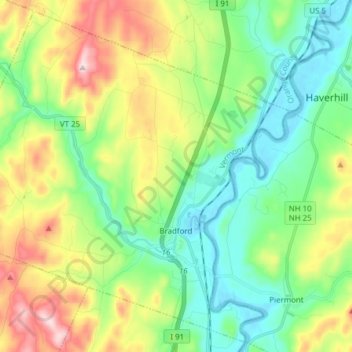
Nom : Carte topographique Bradford, altitude, relief.
Lieu : Bradford, Orange County, Vermont, 05033, United States (43.95741 -72.23283 44.06142 -72.07923)
Altitude moyenne : 255 m
Altitude minimum : 114 m
Altitude maximum : 543 m
According to the United States Census Bureau, the town has a total area of 29.9 square miles (77 km2), of which 29.8 square miles (77 km2) is land and 0.1 square miles (0.26 km2) (0.20%) is water. The Waits River flows through Bradford in a southeasterly direction to its confluence with the Connecticut River, which forms the eastern boundary of the town. The town rises from the river's meadows through low hills and river valleys and finally Wright's Mountain (at an elevation of 1,822 feet) close to the border with Newbury to the north.
Autres cartes topographiques
Cliquez sur une carte pour visualiser sa topographie, son altitude et son relief.
Wells River
United States > Vermont > Orange County
Wells River, Newbury, Orange County, Vermont, 05081, United States
Altitude moyenne : 194 m
Annis Hill
United States > Vermont > Orange County > Chelsea
Annis Hill, Chelsea, Orange County, Vermont, 05036, United States
Altitude moyenne : 511 m
Corinth Corners
United States > Vermont > Orange County > Corinth
Corinth Corners, Corinth, Orange County, Vermont, United States
Altitude moyenne : 502 m
Strafford
United States > Vermont > Orange County
Strafford, Orange County, Vermont, United States
Altitude moyenne : 421 m
Thetford
United States > Vermont > Orange County > Thetford
Thetford, Orange County, Vermont, 05075, United States
Altitude moyenne : 268 m
Newbury
United States > Vermont > Orange County
Newbury, Orange County, Vermont, United States
Altitude moyenne : 264 m
Tunbridge
United States > Vermont > Orange County
Tunbridge, Orange County, Vermont, 05077, United States
Altitude moyenne : 362 m
Orange County
United States > Vermont > Orange County
Orange County, Vermont, United States
Altitude moyenne : 378 m
Randolph
United States > Vermont > Orange County
Randolph, Orange County, Vermont, United States
Altitude moyenne : 367 m