
Carte topographique Lionville
Carte interactive
Cliquez sur la carte pour afficher l’altitude.
À propos de cette carte
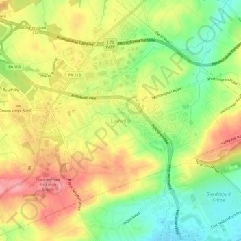
Nom : Carte topographique Lionville, altitude, relief.
Altitude moyenne : 149 m
Altitude minimum : 93 m
Altitude maximum : 203 m
Autres cartes topographiques
Cliquez sur une carte pour visualiser sa topographie, son altitude et son relief.
flood plane
United States > Pennsylvania > Chester County > Uwchlan Township > Lionville
flood plane, Lionville, Uwchlan Township, Chester County, Pennsylvania, United States
Altitude moyenne : 149 m
Eagleview
United States > Pennsylvania > Chester County > Uwchlan Township
Eagleview, Uwchlan Township, Chester County, Pennsylvania, 19480, United States
Altitude moyenne : 151 m