
Carte topographique Cedar Island
Carte interactive
Cliquez sur la carte pour afficher l’altitude.
À propos de cette carte
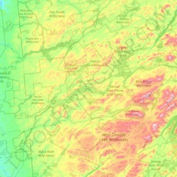
Nom : Carte topographique Cedar Island, altitude, relief.
Altitude moyenne : 589 m
Altitude minimum : 303 m
Altitude maximum : 1’158 m
Autres cartes topographiques
Cliquez sur une carte pour visualiser sa topographie, son altitude et son relief.
Brown Tract Pond Campground
United States > New York > Hamilton County > Town of Inlet
Brown Tract Pond Campground, Town of Inlet, Hamilton County, New York, United States
Altitude moyenne : 564 m