
Carte topographique Waimarama
Carte interactive
Cliquez sur la carte pour afficher l’altitude.
À propos de cette carte
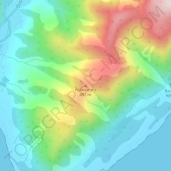
Nom : Carte topographique Waimarama, altitude, relief.
Lieu : Waimarama, Lower Hutt City, Wellington, New Zealand (-41.41840 174.92552 -41.41830 174.92562)
Altitude moyenne : 213 m
Altitude minimum : 0 m
Altitude maximum : 661 m
Autres cartes topographiques
Cliquez sur une carte pour visualiser sa topographie, son altitude et son relief.
Lower Hutt
New Zealand > Wellington > Lower Hutt City
Lower Hutt, Lower Hutt City, Wellington, 5040, New Zealand
Altitude moyenne : 173 m
Wainuiomata River
New Zealand > Wellington > Lower Hutt City
Wainuiomata River, Lower Hutt City, Wellington, New Zealand
Altitude moyenne : 181 m
Hutt Valley
New Zealand > Wellington > Lower Hutt City > Lower Hutt
Hutt Valley, Lower Hutt, Lower Hutt City, Wellington, New Zealand
Altitude moyenne : 212 m
Ōrongorongo River
New Zealand > Wellington > Lower Hutt City
Ōrongorongo River, Lower Hutt City, Wellington, New Zealand
Altitude moyenne : 237 m