
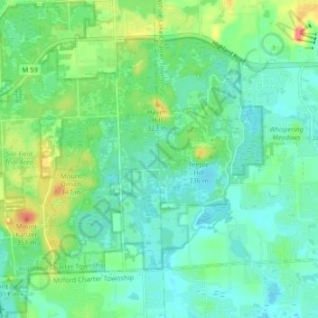
Carte topographique Highland State Recreation Area
Carte interactive
Cliquez sur la carte pour afficher l’altitude.
À propos de cette carte
Nom : Carte topographique Highland State Recreation Area, altitude, relief.
Altitude moyenne : 302 m
Altitude minimum : 282 m
Altitude maximum : 355 m
West of Duck Lake Road in Highland State Recreation Area, a group of small moraines are locally called "mountains"—the highest elevation in the park, Mount Kanzer, is 1,150 feet (350 m) above sea level. The highland for which this recreation area is named is this group of moraines.