
Carte topographique Kawhia
Carte interactive
Cliquez sur la carte pour afficher l’altitude.
À propos de cette carte
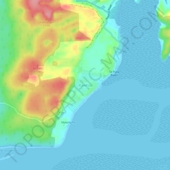
Nom : Carte topographique Kawhia, altitude, relief.
Lieu : Kawhia, Otorohanga District, Waikato, 3843, New Zealand (-38.08511 174.79827 -38.04511 174.83827)
Altitude moyenne : 26 m
Altitude minimum : 0 m
Altitude maximum : 107 m
Autres cartes topographiques
Cliquez sur une carte pour visualiser sa topographie, son altitude et son relief.
Tihiroa
New Zealand > Waikato > Otorohanga District
Tihiroa, Otorohanga District, Waikato, New Zealand
Altitude moyenne : 88 m
Ōparau River
New Zealand > Waikato > Otorohanga District
Ōparau River, Otorohanga District, Waikato, New Zealand
Altitude moyenne : 138 m
Waikeria
New Zealand > Waikato > Otorohanga District
Waikeria, Otorohanga District, Waikato, 3873, New Zealand
Altitude moyenne : 66 m