Géolocaliser

Carte topographique Bicknor

Cliquez sur la carte pour afficher l’altitude.

À propos de cette carte

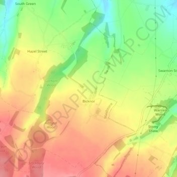
Nom : Carte topographique Bicknor, altitude, relief.

Lieu : Bicknor, Maidstone, Kent, England, United Kingdom (51.28545 0.65484 51.31017 0.68047)

Altitude moyenne : 142 m

Altitude minimum : 91 m

Altitude maximum : 181 m

Autres cartes topographiques

Cliquez sur une carte pour visualiser sa topographie, son altitude et son relief.

Bletchingly

United Kingdom > England > Kent > Maidstone

Altitude moyenne : 37 m

Detling Hill

United Kingdom > England > Kent > Maidstone

Altitude moyenne : 152 m

Mote Park

United Kingdom > England > Kent > Maidstone > Otham

Altitude moyenne : 52 m

Broomfield

United Kingdom > England > Kent > Maidstone > Leeds

Altitude moyenne : 96 m

Langley Park

United Kingdom > England > Kent > Maidstone > Langley

Altitude moyenne : 96 m

Kingswood

United Kingdom > England > Kent > Maidstone

Altitude moyenne : 109 m

Bicknor Wood

United Kingdom > England > Kent > Maidstone > Otham

Altitude moyenne : 85 m

Laddingford

United Kingdom > England > Kent > Maidstone > Yalding

Altitude moyenne : 14 m

East Lenham

United Kingdom > England > Kent > Maidstone > Lenham

Altitude moyenne : 127 m

Linton

United Kingdom > England > Kent > Maidstone

Altitude moyenne : 71 m

Liverton Street

United Kingdom > England > Kent > Maidstone > Grafty Green

Altitude moyenne : 102 m

Westfield Sole

United Kingdom > England > Kent > Maidstone

Altitude moyenne : 145 m

Lenham Heath

United Kingdom > England > Kent > Maidstone

Altitude moyenne : 96 m

Leadingcross Green

United Kingdom > England > Kent > Maidstone > Lenham

Altitude moyenne : 118 m

Bletchenden

United Kingdom > England > Kent > Maidstone > Headcorn

Altitude moyenne : 24 m

Walderslade Woods

United Kingdom > England > Kent > Maidstone

Altitude moyenne : 155 m

Harpole

United Kingdom > England > Kent > Maidstone > Detling

Altitude moyenne : 103 m

Weavering Park

United Kingdom > England > Kent > Maidstone > Grove Green

Altitude moyenne : 56 m

Eyhorne Street

United Kingdom > England > Kent > Maidstone > Hollingbourne

Altitude moyenne : 90 m

Équipez-vous pour votre prochaine aventure :

🔪Couteau multifonction - L'outil polyvalent classique pour tous les imprévus en extérieur
🧊Sac isotherme léger - Gardez vos provisions au frais pendant vos marches d'été
🧥Veste polaire respirante - Couche intermédiaire idéale pour réguler la température corporelle
👕Sous-vêtements Mérinos - Régulation thermique naturelle et anti-odeurs pour plusieurs jours
🪖Casques vélo et VTT - Protection en terrain accidenté

En tant que Partenaire Amazon, ce site perçoit une commission sur les achats éligibles sans surcoût pour vous.