
Faire un don
Équipez-vous pour votre prochaine aventure :
En tant que Partenaire Amazon, ce site perçoit une commission sur les achats éligibles sans surcoût pour vous.
Carte topographique Hopeton
Cliquez sur la carte pour afficher l’altitude.
Faire un don
Équipez-vous pour votre prochaine aventure :
En tant que Partenaire Amazon, ce site perçoit une commission sur les achats éligibles sans surcoût pour vous.
À propos de cette carte
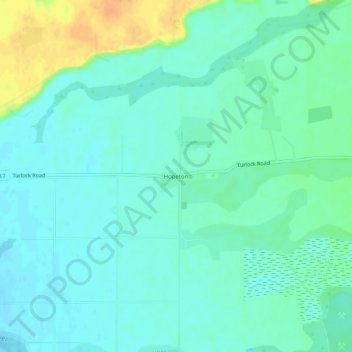
Nom : Carte topographique Hopeton, altitude, relief.
Lieu : Hopeton, Merced County, California, United States (37.47160 -120.55103 37.51160 -120.51103)
Altitude moyenne : 60 m
Altitude minimum : 51 m
Altitude maximum : 85 m
Faire un don
Équipez-vous pour votre prochaine aventure :
En tant que Partenaire Amazon, ce site perçoit une commission sur les achats éligibles sans surcoût pour vous.
Autres cartes topographiques
Cliquez sur une carte pour visualiser sa topographie, son altitude et son relief.
Gustine
United States > California > Merced County
Gustine is a city in Merced County, California. Gustine is located 29 miles (47 km) west of Merced, at an elevation of 98 feet (30 m). At the 2020 census, the city population was 6,110, up from 5,520 at the 2010 census.
Altitude moyenne : 30 m
Faire un don
Équipez-vous pour votre prochaine aventure :
En tant que Partenaire Amazon, ce site perçoit une commission sur les achats éligibles sans surcoût pour vous.
Atwater
United States > California > Merced County
Atwater is a city on State Route 99 in Merced County, California, United States. Atwater is 8 miles (13 km) west-northwest of Merced, at an elevation of 151 feet (46 m). The population as of the 2020 census was 31,970, up from 28,168 in 2010.
Altitude moyenne : 49 m
Los Banos
United States > California > Merced County
Los Banos is located on the west side of the San Joaquin Valley, 26 miles (42 km) southwest of Merced, at approximately 118 ft (36 m) elevation. Its coordinates are 37°03′30″N 120°51′00″W / 37.05833°N 120.85000°W / 37.05833; -120.85000. The city is at the intersection of California State…
Altitude moyenne : 35 m
Faire un don
Équipez-vous pour votre prochaine aventure :
En tant que Partenaire Amazon, ce site perçoit une commission sur les achats éligibles sans surcoût pour vous.
Dos Palos
United States > California > Merced County
Dos Palos (Spanish for "Two Timbers") is a city in Merced County, California, United States. Dos Palos is located 27 miles (43 km) south-southwest of Merced, the county seat, at an elevation of 118 feet (36 m). The population was 5,798 at the 2020 census, up from 4,950 at the 2010 census.
Altitude moyenne : 35 m
Livingston
United States > California > Merced County
Livingston is a city in Merced County, California, United States. Livingston is located 7 miles (11 km) west-northwest of Atwater, at an elevation of 131 feet (40 m). According to the 2020 census, the city population was 14,172, up from 13,058 in 2010. Livingston's total area is 3.7 square miles (9.6 km2),…
Altitude moyenne : 41 m
Los Banos
United States > California > Merced County
Los Banos is located on the west side of the San Joaquin Valley, 26 miles (42 km) southwest of Merced, at about 118 ft (36 m) elevation. Its coordinates are 37°03′30″N 120°51′00″W / 37.05833°N 120.85000°W / 37.05833; -120.85000. The city is at the intersection of California State Route 152…
Altitude moyenne : 36 m
Faire un don
Équipez-vous pour votre prochaine aventure :
En tant que Partenaire Amazon, ce site perçoit une commission sur les achats éligibles sans surcoût pour vous.
Le Grand
United States > California > Merced County
Le Grand (also Legrand) is an unincorporated community and census-designated place (CDP) in Merced County, California, United States. Le Grand is 14 miles (23 km) east-southeast of Merced, the county seat at an elevation of 253 feet (77 m). The population was 1,592 at the 2020 census, down from 1,659 at the…
Altitude moyenne : 78 m
Los Banos
United States > California > Merced County
Los Banos is located on the west side of the San Joaquin Valley, 26 miles (42 km) southwest of Merced, at about 118 ft (36 m) elevation. Its coordinates are 37°03′30″N 120°51′00″W / 37.05833°N 120.85000°W / 37.05833; -120.85000. The city is at the intersection of California State Route 152…
Altitude moyenne : 35 m
Atwater
United States > California > Merced County
Atwater is a city on State Route 99 in Merced County, California, United States. Atwater is 8 miles (13 km) west-northwest of Merced, at an elevation of 151 feet (46 m). The population as of the 2020 census was 31,970, up from 28,168 in 2010.
Altitude moyenne : 50 m
Faire un don
Équipez-vous pour votre prochaine aventure :
En tant que Partenaire Amazon, ce site perçoit une commission sur les achats éligibles sans surcoût pour vous.
Delhi
United States > California > Merced County
Delhi (/ˈdɛlhaɪ/ DEL-hye) is a census-designated place (CDP) in Merced County in the U.S. state of California. Delhi is 18 miles (29 km) west-northwest of Merced, at an elevation of 118 feet (36 m). According to the 2020 census, the population was 10,656.
Altitude moyenne : 39 m
Gustine
United States > California > Merced County
Gustine is a city in Merced County, California. Gustine is located 29 miles (47 km) west of Merced, at an elevation of 98 feet (30 m). At the 2020 census, the city population was 6,110, up from 5,520 at the 2010 census.
Altitude moyenne : 30 m