Géolocaliser

Carte topographique Lundy

Cliquez sur la carte pour afficher l’altitude.

À propos de cette carte

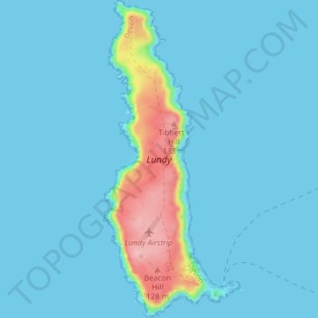
Nom : Carte topographique Lundy, altitude, relief.

Lieu : Lundy, Torridge District, Devon, England, EX39 2LY, United Kingdom (51.15849 -4.68061 51.20252 -4.65310)

Altitude moyenne : 16 m

Altitude minimum : 0 m

Altitude maximum : 144 m

Autres cartes topographiques

Cliquez sur une carte pour visualiser sa topographie, son altitude et son relief.

Woodacott

United Kingdom > England > Devon > Torridge District > Thornbury

Altitude moyenne : 138 m

Chilsworthy

United Kingdom > England > Devon > Torridge District

Altitude moyenne : 139 m

Appledore

United Kingdom > England > Devon > Torridge District

Altitude moyenne : 21 m

Stoke

United Kingdom > England > Devon > Torridge District > Hartland

Altitude moyenne : 76 m

Diddywells

United Kingdom > England > Devon > Torridge District > Northam

Altitude moyenne : 19 m

Riddlecombe

United Kingdom > England > Devon > Torridge District

Altitude moyenne : 156 m

Derril

United Kingdom > England > Devon > Torridge District > Pyworthy

Altitude moyenne : 127 m

Ashmill

United Kingdom > England > Devon > Torridge District > Ashwater

Altitude moyenne : 156 m

Clawton

United Kingdom > England > Devon > Torridge District

Altitude moyenne : 128 m

Westward Ho!

United Kingdom > England > Devon > Torridge District

Altitude moyenne : 22 m

Stibb Cross

United Kingdom > England > Devon > Torridge District

Altitude moyenne : 157 m

Earthquake

United Kingdom > England > Devon > Torridge District

Altitude moyenne : 35 m

Taddiport

United Kingdom > England > Devon > Torridge District

Altitude moyenne : 85 m

Hollocombe

United Kingdom > England > Devon > Torridge District

Altitude moyenne : 149 m

Horns Cross

United Kingdom > England > Devon > Torridge District

Altitude moyenne : 112 m

Équipez-vous pour votre prochaine aventure :

🧢Chapeau de soleil UV - Protection essentielle contre la réverbération solaire en haute altitude
📱Support Smartphone VTT - Gardez vos cartes topographiques numériques visibles sur votre guidon
🧯Trousses de premiers secours - Sécurité et soins en randonnée
🧪Pastilles de purification - Rendez l'eau potable en toutes circonstances lors de vos expéditions
🍯Barres énergétiques - Coup de boost rapide lors des ascensions difficiles

En tant que Partenaire Amazon, ce site perçoit une commission sur les achats éligibles sans surcoût pour vous.