
Carte topographique Thurnau
Carte interactive
Cliquez sur la carte pour afficher l’altitude.
À propos de cette carte
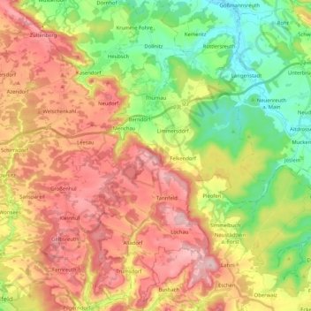
Nom : Carte topographique Thurnau, altitude, relief.
Lieu : Thurnau, Landkreis Kulmbach, Bayern, 95349, Deutschland (49.93374 11.32725 50.06591 11.46692)
Altitude moyenne : 433 m
Altitude minimum : 297 m
Altitude maximum : 582 m
Autres cartes topographiques
Cliquez sur une carte pour visualiser sa topographie, son altitude et son relief.
Kasendorf
Deutschland > Bayern > Landkreis Kulmbach
Kasendorf, Kasendorf (VGem), Landkreis Kulmbach, Bayern, 95359, Deutschland
Altitude moyenne : 425 m
Marktleugast
Deutschland > Bayern > Landkreis Kulmbach
Marktleugast, Marktleugast (VGem), Landkreis Kulmbach, Bayern, Deutschland
Altitude moyenne : 561 m