
Carte topographique Theodore Roosevelt National Park
Carte interactive
Cliquez sur la carte pour afficher l’altitude.
À propos de cette carte
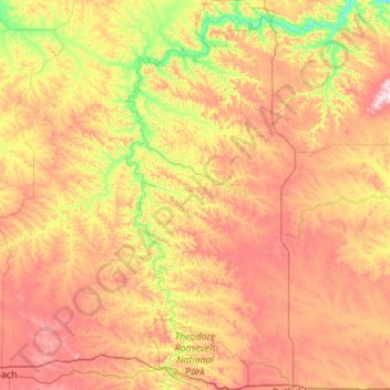
Nom : Carte topographique Theodore Roosevelt National Park, altitude, relief.
Altitude moyenne : 756 m
Altitude minimum : 573 m
Altitude maximum : 1’000 m
The wilderness protects from development the wildest sections of the National Park, an area described as badlands where erosional forces have carved steep cliffs into the relatively flat prairie. Bison, pronghorn, elk, mule deer and coyote are all found here, along with hundreds of species of birds such as the bald eagle, falcon and hawk. The wilderness is separated into two sections along with the park, a north and a south unit, by a distance of 70 miles (110 km). The Little Missouri River is on the south side of both units and is credited for being the primary erosional source which created the badlands topography.
Autres cartes topographiques
Cliquez sur une carte pour visualiser sa topographie, son altitude et son relief.
Medora
United States > North Dakota > Billings County
Medora, Billings County, North Dakota, 58645, United States
Altitude moyenne : 720 m