
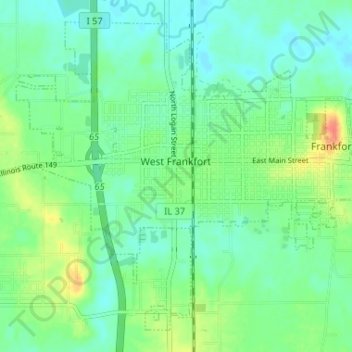
Carte topographique West Frankfort
Carte interactive
Cliquez sur la carte pour afficher l’altitude.
À propos de cette carte
Nom : Carte topographique West Frankfort, altitude, relief.
Altitude moyenne : 122 m
Altitude minimum : 108 m
Altitude maximum : 155 m
The area of West Frankfort formerly known as Frankfort is still sometimes referred to locally as Frankfort Heights or, more commonly, simply as "The Heights", due to its higher elevation relative to the rest of the city. A post office was maintained in Frankfort Heights until its destruction by fire in 2004, making West Frankfort one of the smallest cities in the United States to have two ZIP codes (the other zip code is designated as "Frankfort Heights, Illinois").
Autres cartes topographiques
Cliquez sur une carte pour visualiser sa topographie, son altitude et son relief.
Benton Park
United States > Illinois > Franklin County > Benton
Benton Park, Benton, Franklin County, Illinois, 62897, United States
Altitude moyenne : 138 m
Benton
United States > Illinois > Franklin County
Benton, Franklin County, Illinois, 62812, United States
Altitude moyenne : 132 m
Christopher
United States > Illinois > Franklin County
Christopher, Franklin County, Illinois, 62822, United States
Altitude moyenne : 130 m
Thompsonville
United States > Illinois > Franklin County
Thompsonville, Franklin County, Illinois, United States
Altitude moyenne : 147 m
Royalton
United States > Illinois > Franklin County > Royalton
Royalton, Franklin County, Illinois, United States
Altitude moyenne : 122 m
Rend Lake
United States > Illinois > Franklin County
Rend Lake, Franklin County, Illinois, United States
Altitude moyenne : 132 m