
Carte topographique Tehran
Carte interactive
Cliquez sur la carte pour afficher l’altitude.
À propos de cette carte
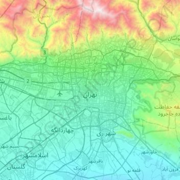
Nom : Carte topographique Tehran, altitude, relief.
Altitude moyenne : 1’539 m
Altitude minimum : 976 m
Altitude maximum : 3’943 m
As the city has a large area, with significant differences in elevation among various districts, the weather is often cooler in the hilly north than in the flat southern part of Tehran. For instance, the 17.3 km (10.7 mi) Valiasr Street runs from Tehran's railway station at 1,117 m (3,665 ft) elevation above sea level in the south of the city to Tajrish Square at 1712.6 m (5612.3 ft) elevation above sea level in the north. However, the elevation can even rise up to 2,000 m (6,600 ft) at the end of Velenjak in northern Tehran. The sparse texture, the existence of old gardens, orchards, green spaces along the highways and the lack of industrial activities in the north of the city have helped the air in the northern areas to be 2 to 3 degrees Celsius cooler than the southern areas of the city.
Autres cartes topographiques
Cliquez sur une carte pour visualiser sa topographie, son altitude et son relief.
بوستان سیما
Iran > Tehran County > Tehran
بوستان سیما, Saeei, District 6, Tehran, بخش مرکزی شهرستان تهران, Tehran County, Tehran Province, Iran
Altitude moyenne : 1’376 m
دهستان سیاهرود
دهستان سیاهرود, بخش مرکزی شهرستان تهران, Tehran County, Tehran Province, Iran
Altitude moyenne : 1’580 m
Laleh Park
Iran > Tehran County > Tehran
Laleh Park, District 6, شهرداری منطقه شش ناحیه یک, Tehran, بخش مرکزی شهرستان تهران, Tehran County, Tehran Province, Iran
Altitude moyenne : 1’245 m
Milad Tower
Iran > Tehran County > Tehran
Milad Tower, مرکز همایش های برج میلاد, Kuy Nasr, District 2, Tehran, بخش مرکزی شهرستان تهران, Tehran County, Tehran Province, 14736-56857, Iran
Altitude moyenne : 1’394 m
Dardasht
Iran > Tehran County > Tehran
Dardasht, District 8, Tehran, بخش مرکزی شهرستان تهران, Tehran County, Tehran Province, Iran
Altitude moyenne : 1’295 m
Arazi Abas Abad
Iran > Tehran County > Tehran
Arazi Abas Abad, District 3, Tehran, بخش مرکزی شهرستان تهران, Tehran County, Tehran Province, Iran
Altitude moyenne : 1’378 m
شهرداری منطقه شش ناحیه یک
Iran > Tehran County > Tehran
شهرداری منطقه شش ناحیه یک, Tehran, بخش مرکزی شهرستان تهران, Tehran County, 15989-35611, Iran
Altitude moyenne : 1’226 m
Sa'i Park
Iran > Tehran County > Tehran
Sa'i Park, District 6, شهرداری منطقه شش ناحیه یک, Tehran, بخش مرکزی شهرستان تهران, Tehran County, Iran
Altitude moyenne : 1’348 m