
Carte topographique Saint-Nazaire
Carte interactive
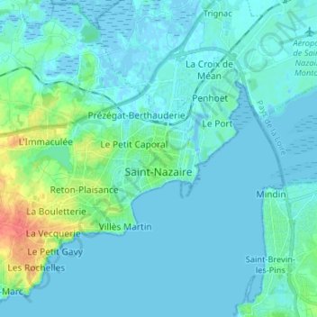
Cliquez sur la carte pour afficher l’altitude.
À propos de cette carte
Nom : Carte topographique Saint-Nazaire, altitude, relief.
Altitude moyenne : 6 m
Altitude minimum : -5 m
Altitude maximum : 46 m
According to INSEE, Saint-Nazaire is the commune-center of an urban unit (commonly: agglomeration) which counted 186,760 inhabitants in 2018, gathering 17 communes of the Loire estuary. This unit is the urban center of the urban area of Saint-Nazaire (24 communes), which had 213,675 inhabitants in 2018 and extending over Brière and almost all of the Guérande peninsula. The eastern part of the town is on the alluvial terrain between the Brière and the Loire estuary. The western part, more extensive, corresponds to the extension of the hillside of Guérande: the relief is hilly and of higher altitude, where one finds a granite and metamorphic base. Geologically, Saint-Nazaire is located in the Armorican massif.
Autres cartes topographiques
Cliquez sur une carte pour visualiser sa topographie, son altitude et son relief.
Savenay
France > Pays de la Loire > Loire-Atlantique
Savenay, Saint-Nazaire, Loire-Atlantique, Pays de la Loire, Metropolitan France, 44260, France
Altitude moyenne : 35 m
Saint-Père-en-Retz
France > Pays de la Loire > Loire-Atlantique > Saint-Père-en-Retz
Saint-Père-en-Retz, Saint-Nazaire, Loire-Atlantique, Pays de la Loire, Metropolitan France, 44320, France
Altitude moyenne : 19 m
Nantes
France > Pays de la Loire > Loire-Atlantique
Nantes, Loire-Atlantique, Pays de la Loire, Metropolitan France, France
Altitude moyenne : 26 m