
Faire un don
Équipez-vous pour votre prochaine aventure :
En tant que Partenaire Amazon, ce site perçoit une commission sur les achats éligibles sans surcoût pour vous.
Carte topographique New Town
Cliquez sur la carte pour afficher l’altitude.
Faire un don
Équipez-vous pour votre prochaine aventure :
En tant que Partenaire Amazon, ce site perçoit une commission sur les achats éligibles sans surcoût pour vous.
À propos de cette carte
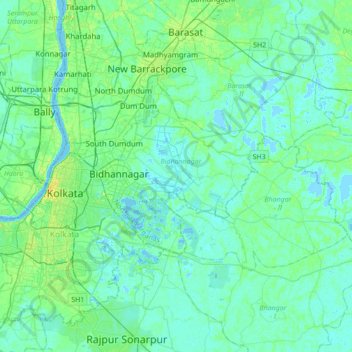
Nom : Carte topographique New Town, altitude, relief.
Altitude moyenne : 5 m
Altitude minimum : -3 m
Altitude maximum : 22 m
Faire un don
Équipez-vous pour votre prochaine aventure :
En tant que Partenaire Amazon, ce site perçoit une commission sur les achats éligibles sans surcoût pour vous.
Autres cartes topographiques
Cliquez sur une carte pour visualiser sa topographie, son altitude et son relief.
Bidhannagar
India > West Bengal > Bidhannagar
According to the Bidhannagar Municipal Corporation, the city area has a total area of 55.51 square kilometres (21.43 sq mi), with approx 30.51 square kilometres (11.78 sq mi) of it being land, and approx 25 square kilometres (9.7 sq mi), or 45.5% of the total, being covered by water. It has an average…
Altitude moyenne : 5 m
Faire un don
Équipez-vous pour votre prochaine aventure :
En tant que Partenaire Amazon, ce site perçoit une commission sur les achats éligibles sans surcoût pour vous.
Bidhannagar
India > West Bengal > Bidhannagar
Bidhannagar is located at 22°35′N 88°25′E / 22.58°N 88.42°E / 22.58; 88.42. It has an average elevation of 11 metres (49 ft).
Altitude moyenne : 5 m
Bidhannagar
India > West Bengal > Bidhannagar
Bidhannagar is located at 22°35′N 88°25′E / 22.58°N 88.42°E / 22.58; 88.42. It has an average elevation of 11 metres (49 ft).
Altitude moyenne : 5 m