
Carte topographique San de Fuca
Carte interactive
Cliquez sur la carte pour afficher l’altitude.
À propos de cette carte
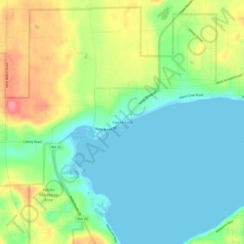
Nom : Carte topographique San de Fuca, altitude, relief.
Lieu : San de Fuca, Island County, Washington, United States (48.21510 -122.74323 48.25510 -122.70323)
Altitude moyenne : 31 m
Altitude minimum : -2 m
Altitude maximum : 91 m
Autres cartes topographiques
Cliquez sur une carte pour visualiser sa topographie, son altitude et son relief.
Oak Harbor
United States > Washington > Island County
Oak Harbor, Island County, Washington, United States
Altitude moyenne : 31 m
Whidbey Island
United States > Washington > Island County
Whidbey Island, Island County, Washington, United States
Altitude moyenne : 45 m
Camano Island
United States > Washington > Island County
Camano Island, Island County, Washington, 98282, United States
Altitude moyenne : 27 m
Ebey's Landing National Historical Reserve
United States > Washington > Island County
Ebey's Landing National Historical Reserve, Island County, Washington, United States
Altitude moyenne : 25 m
Puget Sound
United States > Washington > Island County
Puget Sound, Island County, Washington, United States
Altitude moyenne : 0 m
Bayview
United States > Washington > Island County
Bayview, Island County, Washington, 98260, United States
Altitude moyenne : 47 m
Langley
United States > Washington > Island County
Langley, Island County, Washington, United States
Altitude moyenne : 48 m
Clinton
United States > Washington > Island County
Clinton, Island County, Washington, 98236, United States
Altitude moyenne : 48 m
Keystone
United States > Washington > Island County
Keystone, Island County, Washington, United States
Altitude moyenne : 2 m
Cornet
United States > Washington > Island County
Cornet, Island County, Washington, United States
Altitude moyenne : 54 m
Maxwelton
United States > Washington > Island County
Maxwelton, Island County, Washington, United States
Altitude moyenne : 27 m
Mabana
United States > Washington > Island County
Mabana, Island County, Washington, United States
Altitude moyenne : 23 m
Glendale
United States > Washington > Island County
Glendale, Island County, Washington, 98275, United States
Altitude moyenne : 44 m
Baby Island Heights
United States > Washington > Island County
Baby Island Heights, Island County, Washington, United States
Altitude moyenne : 19 m
Camano
United States > Washington > Island County
Camano, Island County, Washington, 98282, United States
Altitude moyenne : 31 m
Libbey Beach County Park
United States > Washington > Island County
Libbey Beach County Park, Island County, Washington, United States
Altitude moyenne : 21 m
Freeland
United States > Washington > Island County
Freeland, Island County, Washington, 98249, United States
Altitude moyenne : 37 m
Coupeville
United States > Washington > Island County
Coupeville, Island County, Washington, United States
Altitude moyenne : 27 m
Clinton
United States > Washington > Island County > Clinton
Clinton, Island County, Washington, United States
Altitude moyenne : 33 m
Long Beach
United States > Washington > Island County > Long Beach
Long Beach, Island County, Washington, 98282, United States
Altitude moyenne : 11 m
Coupeville, Washington
United States > Washington > Island County
Coupeville, Washington, Island County, Washington, United States
Altitude moyenne : 29 m
Greenbank
United States > Washington > Island County
Greenbank, Island County, Washington, 98253, United States
Altitude moyenne : 39 m
Fort Casey
United States > Washington > Island County
Fort Casey, South Fort Casey Road, Island County, Washington, United States
Altitude moyenne : 1 m