
Carte topographique Budenheim
Carte interactive
Cliquez sur la carte pour afficher l’altitude.
À propos de cette carte
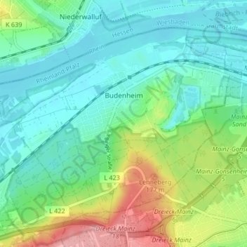
Nom : Carte topographique Budenheim, altitude, relief.
Altitude moyenne : 113 m
Altitude minimum : 79 m
Altitude maximum : 197 m
Budenheim's greatest elevation is the Lenneberg at 176.8 m, which is in the Lennebergwald. At this spot stands the Lennebergturm (tower), dedicated in 1880 and belonging to the Wander- und Lennebergverein Rheingold Mainz e. V. (a hiking club).
Autres cartes topographiques
Cliquez sur une carte pour visualiser sa topographie, son altitude et son relief.
Ingelheim am Rhein
Germany > Rhineland-Palatinate > Landkreis Mainz-Bingen
Ingelheim am Rhein, Landkreis Mainz-Bingen, Rhineland-Palatinate, Germany
Altitude moyenne : 157 m
Oppenheim
Germany > Rhineland-Palatinate > Landkreis Mainz-Bingen
Oppenheim, Rhein-Selz, Landkreis Mainz-Bingen, Rhineland-Palatinate, 55276, Germany
Altitude moyenne : 121 m