
Carte topographique Akuluto
Cliquez sur la carte pour afficher l’altitude.
À propos de cette carte
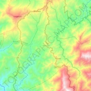
Nom : Carte topographique Akuluto, altitude, relief.
Lieu : Akuluto, Zünheboto District, Nagaland, 798619, India (26.11718 94.40805 26.29261 94.52240)
Altitude moyenne : 954 m
Altitude minimum : 340 m
Altitude maximum : 2’015 m
Autres cartes topographiques
Cliquez sur une carte pour visualiser sa topographie, son altitude et son relief.
Kohima
India > Nagaland > Kohima Sadar
Kohima (/koʊˈhiːmə/ ; Angami Naga: Kewhira (IPA: [ˈkɛʍɪɻə]) is the capital of the Indian state of Nagaland. With a resident population of almost 100,000, it is the second largest city in the state. Kohima constitutes both a district and a municipality. The municipality covers 20 km2 (7.7 sq mi). The…
Altitude moyenne : 1’425 m
Kohima
India > Nagaland > Kohima Sadar
Kohima (/koʊˈhiːmə/ ; Angami Naga: Kewhira (IPA: [ˈkɛʍɪɻə])) is the capital of the North East Indian state of Nagaland. With a resident population of almost 100,000, it is the second largest city in the state. Kohima constitutes both a district and a municipality. The municipality covers 20 km2 (7.7…
Altitude moyenne : 1’425 m