
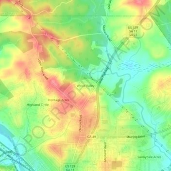
Carte topographique Wood Valley
Carte interactive
Cliquez sur la carte pour afficher l’altitude.
À propos de cette carte
Nom : Carte topographique Wood Valley, altitude, relief.
Altitude moyenne : 120 m
Altitude minimum : 84 m
Altitude maximum : 158 m
Autres cartes topographiques
Cliquez sur une carte pour visualiser sa topographie, son altitude et son relief.
Heritage Acres
United States > Georgia > Bibb County > Macon
Heritage Acres, Macon, Bibb County, Georgia, 31211, United States
Altitude moyenne : 119 m
Sofkee
United States > Georgia > Bibb County > Macon
Sofkee, Macon, Bibb County, Georgia, 31297, United States
Altitude moyenne : 110 m
Avondale
United States > Georgia > Bibb County > Macon
Avondale, Macon, Bibb County, Georgia, 31297, United States
Altitude moyenne : 98 m
Christophers Cove
United States > Georgia > Bibb County > Macon
Christophers Cove, Macon, Bibb County, Georgia, 31220, United States
Altitude moyenne : 130 m
Lake Arrowhead
United States > Georgia > Bibb County > Macon
Lake Arrowhead, Macon, Bibb County, Georgia, 31217, United States
Altitude moyenne : 137 m
Lizella
United States > Georgia > Bibb County > Macon > Lizella
Lizella, Macon, Bibb County, Georgia, 31052, United States
Altitude moyenne : 146 m
Ocmulgee Mounds National Historical Park
United States > Georgia > Bibb County > Macon
Ocmulgee Mounds National Historical Park, Short Circle, Macon, Bibb County, Georgia, 31201-1662, United States
Altitude moyenne : 96 m
Idlewood
United States > Georgia > Bibb County > Macon
Idlewood, Macon, Bibb County, Georgia, 31210, United States
Altitude moyenne : 132 m