
Carte topographique Saint Lawrence
Carte interactive
Cliquez sur la carte pour afficher l’altitude.
À propos de cette carte
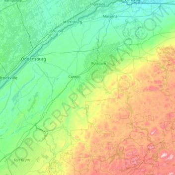
Nom : Carte topographique Saint Lawrence, altitude, relief.
Lieu : Saint Lawrence, New York, United States of America (44.05040 -75.86164 45.01586 -74.52526)
Altitude moyenne : 239 m
Altitude minimum : 44 m
Altitude maximum : 929 m
Autres cartes topographiques
Cliquez sur une carte pour visualiser sa topographie, son altitude et son relief.
Saratoga County
United States of America > New York
Saratoga County, New York, United States of America
Altitude moyenne : 218 m
Farmingville
United States of America > New York
Farmingville, Suffolk County, New York, 11738, United States of America
Altitude moyenne : 47 m
Queens
United States of America > New York > New York
Queens, New York, United States of America
Altitude moyenne : 11 m
Essex County
United States of America > New York
Essex County, New York, United States of America
Altitude moyenne : 418 m
Nassau County
United States of America > New York
Nassau County, New York, United States of America
Altitude moyenne : 18 m
Allegany County
United States of America > New York
Allegany County, New York, United States of America
Altitude moyenne : 561 m
Valley Stream
United States of America > New York > Valley Stream > Valley Stream
Valley Stream, Hempstead, Nassau County, New York, 11580, United States of America
Altitude moyenne : 7 m
New York County
United States of America > New York > New York
New York County, New York, United States of America
Altitude moyenne : 16 m