
Carte topographique Long Green
Carte interactive
Cliquez sur la carte pour afficher l’altitude.
À propos de cette carte
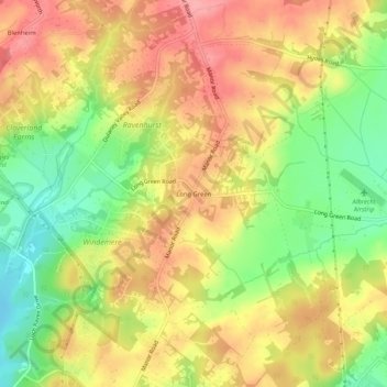
Nom : Carte topographique Long Green, altitude, relief.
Altitude moyenne : 129 m
Altitude minimum : 67 m
Altitude maximum : 181 m
Autres cartes topographiques
Cliquez sur une carte pour visualiser sa topographie, son altitude et son relief.
Hydes
United States > Maryland > Baltimore County > Towson
Hydes, Towson, Baltimore County, Maryland, 21013, United States
Altitude moyenne : 123 m
Brooklandville
United States > Maryland > Baltimore County > Towson
Brooklandville, Towson, Baltimore County, Maryland, 21022, United States
Altitude moyenne : 122 m
Rockland
United States > Maryland > Baltimore County > Towson
Rockland, Towson, Baltimore County, Maryland, 21022, United States
Altitude moyenne : 107 m
Towson
United States > Maryland > Baltimore County > Towson
Towson, Baltimore County, Maryland, United States
Altitude moyenne : 114 m
Greenwood
United States > Maryland > Baltimore County > Towson
Greenwood, Towson, Baltimore County, Maryland, 21057, United States
Altitude moyenne : 93 m
Glen Arm
United States > Maryland > Baltimore County > Towson
Glen Arm, Towson, Baltimore County, Maryland, 21057, United States
Altitude moyenne : 109 m