
Faire un don
Équipez-vous pour votre prochaine aventure :
En tant que Partenaire Amazon, ce site perçoit une commission sur les achats éligibles sans surcoût pour vous.
Carte topographique Bona Qabelanka
Cliquez sur la carte pour afficher l’altitude.
Faire un don
Équipez-vous pour votre prochaine aventure :
En tant que Partenaire Amazon, ce site perçoit une commission sur les achats éligibles sans surcoût pour vous.
À propos de cette carte
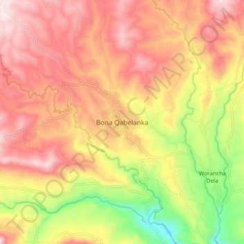
Nom : Carte topographique Bona Qabelanka, altitude, relief.
Lieu : Bona Qabelanka, Sidama, Ethiopia (6.48875 38.67210 6.56875 38.75210)
Altitude moyenne : 2’097 m
Altitude minimum : 1’760 m
Altitude maximum : 2’339 m
Faire un don
Équipez-vous pour votre prochaine aventure :
En tant que Partenaire Amazon, ce site perçoit une commission sur les achats éligibles sans surcoût pour vous.
Autres cartes topographiques
Cliquez sur une carte pour visualiser sa topographie, son altitude et son relief.
Lake Hawassa
Lake Hawassa or Awasa, is an endorheic basin in Sidama Region of Ethiopia, located in the Main Ethiopian Rift south of Addis Ababa, the capital city of the country. According to the Statistical Abstract of Ethiopia for 1967/68, the lake is 16 km long and 9 km wide, with a surface area of 129 square kilometers.…
Altitude moyenne : 1’705 m
Faire un don
Équipez-vous pour votre prochaine aventure :
En tant que Partenaire Amazon, ce site perçoit une commission sur les achats éligibles sans surcoût pour vous.