
Carte topographique Ishpeming
Carte interactive
Cliquez sur la carte pour afficher l’altitude.
À propos de cette carte
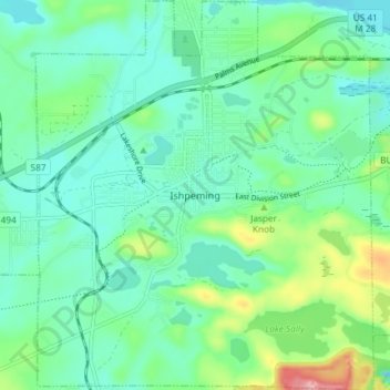
Nom : Carte topographique Ishpeming, altitude, relief.
Lieu : Ishpeming, Marquette County, Michigan, United States (46.46306 -87.69786 46.51389 -87.63378)
Altitude moyenne : 449 m
Altitude minimum : 411 m
Altitude maximum : 569 m
Ishpeming is in central Marquette County, 15 miles (24 km) west of Marquette, the county seat. It is bordered to the east by the city of Negaunee. According to the United States Census Bureau, Ishpeming has a total area of 9.35 square miles (24.22 km2), of which 8.74 square miles (22.64 km2) are land and 0.61 square miles (1.58 km2), or 6.50%, are water. Ishpeming's elevation is 1,436 feet (438 m) above mean sea level, which is over 800 feet (240 m) higher than that of nearby Lake Superior. The highlands of Ishpeming and the surrounding area, including the city of Negaunee to its east, receive an unusually high yearly average of lake-effect snow.
Autres cartes topographiques
Cliquez sur une carte pour visualiser sa topographie, son altitude et son relief.
Marquette
United States > Michigan > Marquette County
Marquette, Marquette County, Michigan, 49855, United States
Altitude moyenne : 215 m
Huron River Point
United States > Michigan > Marquette County
Huron River Point, Powell Township, Marquette County, Michigan, United States
Altitude moyenne : 188 m
West Ishpeming
United States > Michigan > Marquette County
West Ishpeming, Ishpeming Township, Marquette County, Michigan, United States
Altitude moyenne : 445 m
Sand River
United States > Michigan > Marquette County
Sand River, Chocolay Township, Marquette County, Michigan, United States
Altitude moyenne : 231 m
Ely Township
United States > Michigan > Marquette County
Ely Township, Marquette County, Michigan, United States
Altitude moyenne : 450 m
Chocolay Township
United States > Michigan > Marquette County
Chocolay Township, Marquette County, Michigan, United States
Altitude moyenne : 217 m
Skandia
United States > Michigan > Marquette County
Skandia, West Branch Township, Marquette County, Michigan, 49885, United States
Altitude moyenne : 274 m
Big Bay
United States > Michigan > Marquette County
Big Bay, Powell Township, Marquette County, Michigan, 49808, United States
Altitude moyenne : 218 m
Gwinn
United States > Michigan > Marquette County
Gwinn, Forsyth Township, Marquette County, Michigan, United States
Altitude moyenne : 345 m
Republic
United States > Michigan > Marquette County > Republic
Republic, Republic Township, Marquette County, Michigan, United States
Altitude moyenne : 467 m
Ewing Township
United States > Michigan > Marquette County
Ewing Township, Marquette County, Michigan, United States
Altitude moyenne : 302 m
Negaunee
United States > Michigan > Marquette County
Negaunee, Marquette County, Michigan, 49866, United States
Altitude moyenne : 441 m
Michigamme Township
United States > Michigan > Marquette County
Michigamme Township, Marquette County, Michigan, 49861, United States
Altitude moyenne : 494 m