
Carte topographique Boornbergum
Carte interactive
Cliquez sur la carte pour afficher l’altitude.
À propos de cette carte
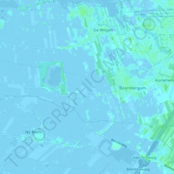
Nom : Carte topographique Boornbergum, altitude, relief.
Lieu : Boornbergum, Smallingerland, Friesland, Niederlande (53.07208 5.98806 53.09435 6.06990)
Altitude moyenne : 0 m
Altitude minimum : -4 m
Altitude maximum : 5 m
Autres cartes topographiques
Cliquez sur une carte pour visualiser sa topographie, son altitude et son relief.
Goëngahuizen
Niederlande > Friesland > Smallingerland
Goëngahuizen, Smallingerland, Friesland, Niederlande
Altitude moyenne : 0 m
Drachtstercompagnie
Niederlande > Friesland > Smallingerland
Drachtstercompagnie, Smallingerland, Friesland, Niederlande
Altitude moyenne : 4 m
De Veenhoop
Niederlande > Friesland > Smallingerland
De Veenhoop, Smallingerland, Friesland, Niederlande
Altitude moyenne : -1 m
Smalle Ee
Niederlande > Friesland > Smallingerland
Smalle Ee, Smallingerland, Friesland, Niederlande
Altitude moyenne : 0 m
Houtigehage
Niederlande > Friesland > Smallingerland
Houtigehage, Smallingerland, Friesland, Niederlande
Altitude moyenne : 3 m