
Carte topographique Abbeville
Carte interactive
Cliquez sur la carte pour afficher l’altitude.
À propos de cette carte
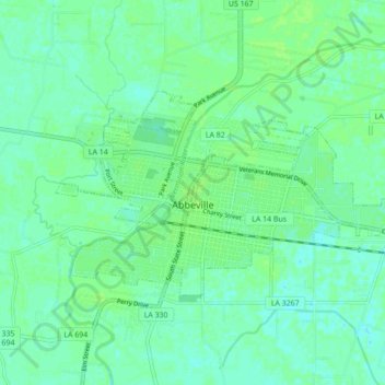
Nom : Carte topographique Abbeville, altitude, relief.
Lieu : Abbeville, Vermilion Parish, Louisiana, 70510, United States (29.95691 -92.16533 29.99695 -92.07840)
Altitude moyenne : 5 m
Altitude minimum : -1 m
Altitude maximum : 9 m
Abbeville is located at 29°58′31.422″N 92°7′37.7652″W / 29.97539500°N 92.127157000°W / 29.97539500; -92.127157000 and has an elevation of 16 feet (4.9 m). According to the United States Census Bureau, the town has a total area of 5.7 square miles (14.7629 km2), of which 5.7 square miles (15 km2) is land and 0.04 square miles (0.10 km2) (0.53%) is water. Abbeville is located near the southern terminus of U.S. Highway 167. Abbeville Chris Crusta Memorial Airport is in the eastern part of the city. The Vermilion River runs through downtown, and several canals and coulees run through other parts of Abbeville.
Autres cartes topographiques
Cliquez sur une carte pour visualiser sa topographie, son altitude et son relief.
Kaplan
United States > Louisiana > Vermilion Parish
Kaplan, Vermilion Parish, Louisiana, United States
Altitude moyenne : 5 m
Indian Bayou
United States > Louisiana > Vermilion Parish
Indian Bayou, Vermilion Parish, Louisiana, United States
Altitude moyenne : 7 m
Rose Hill
United States > Louisiana > Vermilion Parish > Rose Hill
Rose Hill, Vermilion Parish, Louisiana, 70575, United States
Altitude moyenne : 3 m