
Carte topographique Sekiu
Carte interactive
Cliquez sur la carte pour afficher l’altitude.
À propos de cette carte
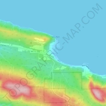
Nom : Carte topographique Sekiu, altitude, relief.
Lieu : Sekiu, Clallam County, Washington, United States (48.24230 -124.32133 48.28230 -124.28133)
Altitude moyenne : 59 m
Altitude minimum : -2 m
Altitude maximum : 234 m
Sekiu Airport is located a mile west of Sekiu and offers a 2,997-foot (913 m) lighted runway with a visual approach indicator, at an elevation of 350 feet (110 m).
Autres cartes topographiques
Cliquez sur une carte pour visualiser sa topographie, son altitude et son relief.
Port Angeles
United States > Washington > Clallam County
Port Angeles, Clallam County, Washington, 98362, United States
Altitude moyenne : 27 m
Sequim
United States > Washington > Clallam County
Sequim, Clallam County, Washington, United States
Altitude moyenne : 88 m
Hurricane Ridge
United States > Washington > Clallam County
Hurricane Ridge, Hurricane Ridge Road, Clallam County, Washington, United States
Altitude moyenne : 1’331 m
Diamond Point
United States > Washington > Clallam County
Diamond Point, Clallam County, Washington, United States
Altitude moyenne : 14 m
Bell Hill
United States > Washington > Clallam County > Bell Hill
Bell Hill, Clallam County, Washington, United States
Altitude moyenne : 139 m
Joyce
United States > Washington > Clallam County
Joyce, Clallam County, Washington, United States
Altitude moyenne : 141 m
Sappho
United States > Washington > Clallam County
Sappho, Clallam County, Washington, United States
Altitude moyenne : 172 m
Port Williams
United States > Washington > Clallam County
Port Williams, Clallam County, Washington, United States
Altitude moyenne : 12 m
Elwha
United States > Washington > Clallam County
Elwha, Clallam County, Washington, United States
Altitude moyenne : 278 m
Pysht
United States > Washington > Clallam County
Pysht, Clallam County, Washington, United States
Altitude moyenne : 52 m
Agnew
United States > Washington > Clallam County
Agnew, Clallam County, Washington, United States
Altitude moyenne : 54 m
Gettysburg Ranch
United States > Washington > Clallam County
Gettysburg Ranch, Clallam County, Washington, United States
Altitude moyenne : 19 m
Rena
United States > Washington > Clallam County
Rena, Clallam County, Washington, 98324, United States
Altitude moyenne : 69 m
Beaver
United States > Washington > Clallam County
Beaver, Clallam County, Washington, United States
Altitude moyenne : 184 m
Piedmont
United States > Washington > Clallam County
Piedmont, Clallam County, Washington, United States
Altitude moyenne : 344 m
Carlsborg
United States > Washington > Clallam County
Carlsborg, Clallam County, Washington, 98324, United States
Altitude moyenne : 73 m
Mora
United States > Washington > Clallam County
Mora, Clallam County, Washington, 98350, United States
Altitude moyenne : 29 m
Maple Grove
United States > Washington > Clallam County
Maple Grove, Clallam County, Washington, United States
Altitude moyenne : 385 m
Crane
United States > Washington > Clallam County
Crane, Clallam County, Washington, United States
Altitude moyenne : 61 m
Jamestown
United States > Washington > Clallam County
Jamestown, Clallam County, Washington, United States
Altitude moyenne : 7 m
Dungeness
United States > Washington > Clallam County
Dungeness, Clallam County, Washington, United States
Altitude moyenne : 5 m
James Island
United States > Washington > Clallam County > La Push
James Island, La Push, Clallam County, Washington, United States
Altitude moyenne : 1 m
Happy Valley
United States > Washington > Clallam County
Happy Valley, Clallam County, Washington, United States
Altitude moyenne : 237 m
Port Angeles East
United States > Washington > Clallam County > Mount Pleasant
Port Angeles East, Mount Pleasant, Clallam County, Washington, United States
Altitude moyenne : 59 m
Clallam Bay
United States > Washington > Clallam County
Clallam Bay, Clallam County, Washington, United States
Altitude moyenne : 39 m
Lake Crescent
United States > Washington > Clallam County
Lake Crescent, Clallam County, Washington, United States
Altitude moyenne : 564 m
Quileute Indian Reservation
United States > Washington > Clallam County
Quileute Indian Reservation, Clallam County, Washington, 98350, United States
Altitude moyenne : 29 m
Neah Bay
United States > Washington > Clallam County
Neah Bay, Clallam County, Washington, 98357, United States
Altitude moyenne : 72 m
Quillayute
United States > Washington > Clallam County > Quillayute
Quillayute, Clallam County, Washington, United States
Altitude moyenne : 46 m
La Push
United States > Washington > Clallam County
La Push, Clallam County, Washington, 98350, United States
Altitude moyenne : 17 m
Eagle Point
United States > Washington > Clallam County
Eagle Point, Clallam County, Washington, United States
Altitude moyenne : 1’534 m
Baldy
United States > Washington > Clallam County
Baldy, Clallam County, Washington, United States
Altitude moyenne : 1’722 m
Forks
United States > Washington > Clallam County
Forks, Clallam County, Washington, United States
Altitude moyenne : 113 m
River Road
United States > Washington > Clallam County > River Road
River Road, Clallam County, Washington, United States
Altitude moyenne : 97 m
Cape Flattery
United States > Washington > Clallam County
Cape Flattery, Clallam County, Washington, United States
Altitude moyenne : 33 m