
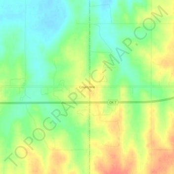
Carte topographique Countyline
Carte interactive
Cliquez sur la carte pour afficher l’altitude.
À propos de cette carte
Nom : Carte topographique Countyline, altitude, relief.
Lieu : Countyline, Stephens County, Oklahoma, 73425, United States (34.42870 -97.58281 34.46870 -97.54281)
Altitude moyenne : 310 m
Altitude minimum : 285 m
Altitude maximum : 338 m
Autres cartes topographiques
Cliquez sur une carte pour visualiser sa topographie, son altitude et son relief.
Bray
United States > Oklahoma > Stephens County
Bray, Stephens County, Oklahoma, United States
Altitude moyenne : 368 m
Velma
United States > Oklahoma > Stephens County
Velma, Stephens County, Oklahoma, 73491, United States
Altitude moyenne : 320 m
Comanche
United States > Oklahoma > Stephens County
Comanche, Stephens County, Oklahoma, 73529, United States
Altitude moyenne : 315 m
Loco
United States > Oklahoma > Stephens County
Loco, Stephens County, Oklahoma, United States
Altitude moyenne : 288 m
Marlow
United States > Oklahoma > Stephens County
Marlow, Stephens County, Oklahoma, 73055, United States
Altitude moyenne : 385 m
Duncan
United States > Oklahoma > Stephens County
Duncan, Stephens County, Oklahoma, 73533, United States
Altitude moyenne : 350 m