
Carte topographique Moka
Carte interactive
Cliquez sur la carte pour afficher l’altitude.
À propos de cette carte
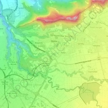
Nom : Carte topographique Moka, altitude, relief.
Lieu : Moka, Mauritius (-20.25158 57.47433 -20.20542 57.53319)
Altitude moyenne : 331 m
Altitude minimum : 88 m
Altitude maximum : 685 m
Moka (Mauritian Creole pronunciation: [moka]) is a village in Mauritius located mainly in the Moka District. The western part of the village lies in the Plaines Wilhems District. Since 1967 it forms part of Constituency No. 8 Quartier Militaire and Moka. The village is administered by the Moka Village Council under the aegis of the Moka District Council. According to the census made by Statistics Mauritius in 2011, the population was at 8,846. The elevation is 203 meters and can be up to 425 meters in some places. Moka is directly on the other side of the Moka Range from Port Louis. The village is close to the mountain Le Pouce and the town Beau-Bassin Rose-Hill. Réduit is a suburb of the village where the State House and University of Mauritius is situated. The village is also home to the Mauritius Broadcasting Corporation and the Mahatma Gandhi Institute.
Autres cartes topographiques
Cliquez sur une carte pour visualiser sa topographie, son altitude et son relief.
Calebasses Mountain
Mauritius > Moka > Nouvelle Découverte
Calebasses Mountain, Nouvelle Découverte, Moka, Outer islands of Mauritius, Mauritius
Altitude moyenne : 370 m