
Faire un don
Équipez-vous pour votre prochaine aventure :
En tant que Partenaire Amazon, ce site perçoit une commission sur les achats éligibles sans surcoût pour vous.
Carte topographique Zangberg
Cliquez sur la carte pour afficher l’altitude.
Faire un don
Équipez-vous pour votre prochaine aventure :
En tant que Partenaire Amazon, ce site perçoit une commission sur les achats éligibles sans surcoût pour vous.
Zangberg
Das Ortsbild wird bestimmt durch den im 17. Jahrhundert entstandenen Bau des heutigen Klosters St. Josef. In den Räumen der früheren Höhere-Töchter-Schule der Salesianerinnen Zangberg, deren berühmteste Schülerin wohl Zita von Bourbon-Parma war, befinden sich heute auch die BSH Academy der BSH Hausgeräte GmbH sowie Schulungsräume der Capgemini sd&m.
Faire un don
Équipez-vous pour votre prochaine aventure :
En tant que Partenaire Amazon, ce site perçoit une commission sur les achats éligibles sans surcoût pour vous.
À propos de cette carte
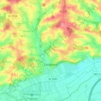
Nom : Carte topographique Zangberg, altitude, relief.
Altitude moyenne : 440 m
Altitude minimum : 403 m
Altitude maximum : 492 m
Faire un don
Équipez-vous pour votre prochaine aventure :
En tant que Partenaire Amazon, ce site perçoit une commission sur les achats éligibles sans surcoût pour vous.
Autres cartes topographiques
Cliquez sur une carte pour visualiser sa topographie, son altitude et son relief.
Leoprechting
Deutschland > Bayern > Landkreis Mühldorf am Inn > Niedertaufkirchen
Altitude moyenne : 466 m
Faire un don
Équipez-vous pour votre prochaine aventure :
En tant que Partenaire Amazon, ce site perçoit une commission sur les achats éligibles sans surcoût pour vous.
Heisting
Deutschland > Bayern > Landkreis Mühldorf am Inn > Kraiburg > Frauendorf
Altitude moyenne : 412 m
Faire un don
Équipez-vous pour votre prochaine aventure :
En tant que Partenaire Amazon, ce site perçoit une commission sur les achats éligibles sans surcoût pour vous.
Faire un don
Équipez-vous pour votre prochaine aventure :
En tant que Partenaire Amazon, ce site perçoit une commission sur les achats éligibles sans surcoût pour vous.
Faire un don
Équipez-vous pour votre prochaine aventure :
En tant que Partenaire Amazon, ce site perçoit une commission sur les achats éligibles sans surcoût pour vous.
Faire un don
Équipez-vous pour votre prochaine aventure :
En tant que Partenaire Amazon, ce site perçoit une commission sur les achats éligibles sans surcoût pour vous.
Oberwiesbach
Deutschland > Bayern > Landkreis Mühldorf am Inn > Neumarkt-Sankt Veit > Wiesbach
Altitude moyenne : 480 m
Sankt Erasmus
Deutschland > Bayern > Landkreis Mühldorf am Inn > Waldkraiburg
Altitude moyenne : 418 m
Faire un don
Équipez-vous pour votre prochaine aventure :
En tant que Partenaire Amazon, ce site perçoit une commission sur les achats éligibles sans surcoût pour vous.
Forchöd
Deutschland > Bayern > Landkreis Mühldorf am Inn > Haag in Oberbayern
Altitude moyenne : 508 m
Faire un don
Équipez-vous pour votre prochaine aventure :
En tant que Partenaire Amazon, ce site perçoit une commission sur les achats éligibles sans surcoût pour vous.
Teising
Deutschland > Bayern > Landkreis Mühldorf am Inn > Neumarkt-Sankt Veit
Altitude moyenne : 464 m
Schloss Teising
Deutschland > Bayern > Landkreis Mühldorf am Inn > Neumarkt-Sankt Veit > Teising
Altitude moyenne : 461 m
Altdorf
Deutschland > Bayern > Landkreis Mühldorf am Inn > Haag in Oberbayern
Altitude moyenne : 526 m
Faire un don
Équipez-vous pour votre prochaine aventure :
En tant que Partenaire Amazon, ce site perçoit une commission sur les achats éligibles sans surcoût pour vous.
Mühldorf am Inn
Deutschland > Bayern > Landkreis Mühldorf am Inn > Mühldorf a. Inn > Mühldorf am Inn
Altitude moyenne : 402 m
Faire un don
Équipez-vous pour votre prochaine aventure :
En tant que Partenaire Amazon, ce site perçoit une commission sur les achats éligibles sans surcoût pour vous.
Furth
Deutschland > Bayern > Landkreis Mühldorf am Inn > Oberflossing > Furth
Altitude moyenne : 418 m
Zaismaier
Deutschland > Bayern > Landkreis Mühldorf am Inn > Stefanskirchen > Zaismaier
Altitude moyenne : 447 m
Schloss Guttenburg
Deutschland > Bayern > Landkreis Mühldorf am Inn > Kraiburg > Frauendorf
Altitude moyenne : 427 m
Faire un don
Équipez-vous pour votre prochaine aventure :
En tant que Partenaire Amazon, ce site perçoit une commission sur les achats éligibles sans surcoût pour vous.
Manholding
Deutschland > Bayern > Landkreis Mühldorf am Inn > Oberbergkirchen
Altitude moyenne : 480 m
Faire un don
Équipez-vous pour votre prochaine aventure :
En tant que Partenaire Amazon, ce site perçoit une commission sur les achats éligibles sans surcoût pour vous.