
Carte topographique Gila Wilderness
Carte interactive
Cliquez sur la carte pour afficher l’altitude.
À propos de cette carte
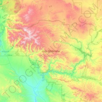
Nom : Carte topographique Gila Wilderness, altitude, relief.
Lieu : Gila Wilderness, Catron County, New Mexico, United States (33.00793 -108.81918 33.41853 -108.00968)
Altitude moyenne : 2’085 m
Altitude minimum : 1’340 m
Altitude maximum : 3’327 m
The Gila Wilderness is located in southwest New Mexico, north of Silver City and east of Reserve. It contains the West Fork, Middle Fork and much of the East Fork of the Gila River; riverside elevations of around 4,850 feet (1,480 m) are the lowest in the wilderness. The Mogollon Mountains traverse an arc across the wilderness. The tallest peak within this range, Whitewater Baldy at 10,895 ft (3,321 m), is in the northwest part of the wilderness along with several other summits more than 10,000 ft (3,048 m) high. At the northeast corner is prominent Black Mountain rising to 9,287 ft (2,831 m). The Gila Cliff Dwellings National Monument is adjacent to the wilderness.
Autres cartes topographiques
Cliquez sur une carte pour visualiser sa topographie, son altitude et son relief.
Prairie Lake
United States > New Mexico > Catron County
Prairie Lake, Catron County, New Mexico, United States
Altitude moyenne : 2’342 m
San Francisco
United States > New Mexico > Catron County
San Francisco, Catron County, New Mexico, United States
Altitude moyenne : 2’440 m
Quemado
United States > New Mexico > Catron County
Quemado, Catron County, New Mexico, United States
Altitude moyenne : 2’113 m
Alma
United States > New Mexico > Catron County
Alma, Catron County, New Mexico, United States
Altitude moyenne : 1’535 m
Capital Dome
United States > New Mexico > Catron County
Capital Dome, Catron County, New Mexico, United States
Altitude moyenne : 2’459 m
Cruzville
United States > New Mexico > Catron County
Cruzville, Catron County, New Mexico, United States
Altitude moyenne : 1’975 m
Reserve
United States > New Mexico > Catron County
Reserve, Catron County, New Mexico, United States
Altitude moyenne : 1’780 m
Datil
United States > New Mexico > Catron County
Datil, Catron County, New Mexico, United States
Altitude moyenne : 2’279 m
San Francisco Mountains
United States > New Mexico > Catron County
San Francisco Mountains, Catron County, New Mexico, United States
Altitude moyenne : 2’541 m
Pie Town
United States > New Mexico > Catron County
Pie Town, Catron County, New Mexico, 87827, United States
Altitude moyenne : 2’352 m