
Carte topographique Heuvelland
Carte interactive
Cliquez sur la carte pour afficher l’altitude.
À propos de cette carte
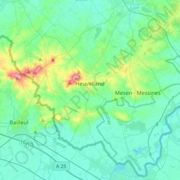
Nom : Carte topographique Heuvelland, altitude, relief.
Lieu : Heuvelland, Ieper, West Flanders, Belgium (50.70828 2.71302 50.82732 2.96047)
Altitude moyenne : 35 m
Altitude minimum : 9 m
Altitude maximum : 152 m
Autres cartes topographiques
Cliquez sur une carte pour visualiser sa topographie, son altitude et son relief.
Zonnebeke
Belgium > West Flanders > Ieper
Zonnebeke, Ieper, West Flanders, Flanders, 8980, Belgium
Altitude moyenne : 30 m
Poperinge
Belgium > West Flanders > Ieper
Poperinge, Ieper, West Flanders, Belgium
Altitude moyenne : 23 m
Zillebeke
Belgium > West Flanders > Ieper > Ypres
Zillebeke, Ypres, Ieper, West Flanders, Flanders, 8902, Belgium
Altitude moyenne : 36 m
Mesen
Belgium > West Flanders > Ieper > Mesen - Messines
Mesen, Mesen - Messines, Mesen, Ieper, West Flanders, Flanders, 8957, Belgium
Altitude moyenne : 38 m
Wijtschate
Belgium > West Flanders > Ieper > Heuvelland
Wijtschate, Heuvelland, Ieper, West Flanders, Flanders, 8953, Belgium
Altitude moyenne : 42 m
Langemark
Belgium > West Flanders > Ieper
Langemark, Langemark - Poelkapelle, Ieper, West Flanders, Flanders, 8920, Belgium
Altitude moyenne : 16 m
Dikkebus
Belgium > West Flanders > Ieper > Ypres
Dikkebus, Ypres, Ieper, West Flanders, Belgium
Altitude moyenne : 31 m
Passchendaele
Belgium > West Flanders > Ieper > Zonnebeke
Passchendaele, Zonnebeke, Ieper, West Flanders, Flanders, Belgium
Altitude moyenne : 34 m
Ypres
Belgium > West Flanders > Ieper > Ypres
Ypres, Ieper, West Flanders, Flanders, 8900, Belgium
Altitude moyenne : 24 m
Westouter
Belgium > West Flanders > Ieper > Heuvelland
Westouter, Heuvelland, Ieper, West Flanders, Flanders, 8954, Belgium
Altitude moyenne : 59 m
Kemmel
Belgium > West Flanders > Ieper > Heuvelland
Kemmel, Heuvelland, Ieper, West Flanders, Flanders, 8956, Belgium
Altitude moyenne : 49 m
Loker
Belgium > West Flanders > Ieper > Heuvelland
Loker, Heuvelland, Ieper, West Flanders, Flanders, 8958, Belgium
Altitude moyenne : 73 m
Wervik
Belgium > West Flanders > Ieper
Wervik, Ieper, West Flanders, 8940, Belgium
Altitude moyenne : 25 m
Wervik
Belgium > West Flanders > Ieper > Wervik
Wervik, Ieper, West Flanders, Flanders, Belgium
Altitude moyenne : 22 m