
Carte topographique Rathen
Carte interactive
Cliquez sur la carte pour afficher l’altitude.
À propos de cette carte
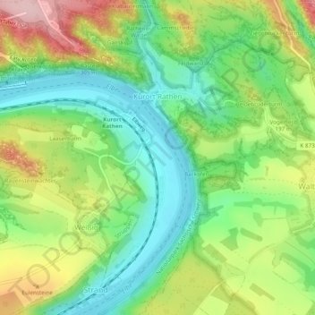
Nom : Carte topographique Rathen, altitude, relief.
Altitude moyenne : 194 m
Altitude minimum : 110 m
Altitude maximum : 324 m
Autres cartes topographiques
Cliquez sur une carte pour visualiser sa topographie, son altitude et son relief.
Kleiner Sandberg
Germany > Saxony > Sächsische Schweiz-Osterzgebirge > Lohmen
Kleiner Sandberg, Lohmen, Lohmen/Stadt Wehlen, Sächsische Schweiz-Osterzgebirge, Saxony, 01829, Germany
Altitude moyenne : 266 m
Malter
Germany > Saxony > Sächsische Schweiz-Osterzgebirge > Dippoldiswalde
Malter, Dippoldiswalde, Sächsische Schweiz-Osterzgebirge, Saxony, 01734, Germany
Altitude moyenne : 371 m
Lohmen
Germany > Saxony > Sächsische Schweiz-Osterzgebirge > Lohmen
Lohmen, Lohmen/Stadt Wehlen, Sächsische Schweiz-Osterzgebirge, Saxony, 01847, Germany
Altitude moyenne : 226 m
Siamesische Zwillinge, Dick
Germany > Saxony > Sächsische Schweiz-Osterzgebirge > Bad Schandau
Siamesische Zwillinge, Dick, Bad Schandau, Sächsische Schweiz-Osterzgebirge, Saxony, Germany
Altitude moyenne : 366 m
Pirna
Germany > Saxony > Sächsische Schweiz-Osterzgebirge
Pirna, Sächsische Schweiz-Osterzgebirge, Saxony, 01796, Germany
Altitude moyenne : 199 m
Bad Schandau
Germany > Saxony > Sächsische Schweiz-Osterzgebirge > Bad Schandau
Bad Schandau, Sächsische Schweiz-Osterzgebirge, Saxony, 01814, Germany
Altitude moyenne : 301 m
Altenberg
Germany > Saxony > Sächsische Schweiz-Osterzgebirge
Altenberg, Sächsische Schweiz-Osterzgebirge, Saxony, Germany
Altitude moyenne : 655 m
Mandarin
Germany > Saxony > Sächsische Schweiz-Osterzgebirge > Rosenthal-Bielatal
Mandarin, Rosenthal-Bielatal, Königstein/Sächs. Schw., Sächsische Schweiz-Osterzgebirge, Saxony, Germany
Altitude moyenne : 428 m