
Carte topographique Bury St Edmunds
Carte interactive
Cliquez sur la carte pour afficher l’altitude.
À propos de cette carte
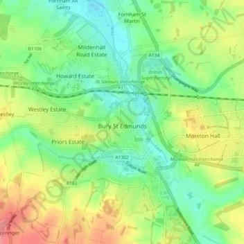
Nom : Carte topographique Bury St Edmunds, altitude, relief.
Lieu : Bury St Edmunds, West Suffolk, Suffolk, England, United Kingdom (52.22234 0.67387 52.27133 0.76382)
Altitude moyenne : 54 m
Altitude minimum : 24 m
Altitude maximum : 98 m
The name Bury is etymologically connected with borough, which has cognates in other Germanic languages such as German Burg 'fortress, castle' and Bereich '(defined) area' Old Norse borg 'wall, castle'; and Gothic baurg 'city'. They all derive from Proto-Germanic *burgs 'fortress'. This in turn derives from the Proto-Indo-European root *bhrgh 'fortified elevation', with cognates including Welsh bera 'stack' and Sanskrit bhrant- 'high, elevated building'.
Autres cartes topographiques
Cliquez sur une carte pour visualiser sa topographie, son altitude et son relief.
Newmarket
United Kingdom > England > Suffolk > West Suffolk
Newmarket, West Suffolk, Suffolk, England, United Kingdom
Altitude moyenne : 45 m
Hargrave
United Kingdom > England > Suffolk > West Suffolk
Hargrave, West Suffolk, Suffolk, England, United Kingdom
Altitude moyenne : 108 m