
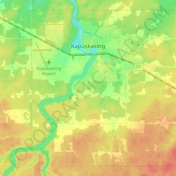
Carte topographique Kapuskasing
Carte interactive
Cliquez sur la carte pour afficher l’altitude.
À propos de cette carte
Nom : Carte topographique Kapuskasing, altitude, relief.
Altitude moyenne : 227 m
Altitude minimum : 202 m
Altitude maximum : 249 m
Kapuskasing lies in the heart of the Great Clay Belt. The topography of the region is very flat, dotted with numerous small lakes and muskeg bogs. Also in the heart of Canada's boreal forest, the region is drained by rivers running north to James Bay. The district is heavily forested, mostly by thick stands of black spruce that have commercial value as pulpwood.
Autres cartes topographiques
Cliquez sur une carte pour visualiser sa topographie, son altitude et son relief.
Moosonee
Canada > Ontario > Cochrane District
Moosonee, Cochrane District, Northeastern Ontario, Ontario, P0L 1Y0, Canada
Altitude moyenne : 13 m
Heart Lake
Canada > Ontario > Cochrane District > Timmins
Heart Lake, Timmins, Cochrane District, Northeastern Ontario, Ontario, Canada
Altitude moyenne : 294 m
Shallow River
Canada > Ontario > Cochrane District > Iroquois Falls
Shallow River, Iroquois Falls, Cochrane District, Northeastern Ontario, Ontario, Canada
Altitude moyenne : 272 m
Wavell
Canada > Ontario > Cochrane District > Black River-Matheson Township
Wavell, Black River-Matheson Township, Cochrane District, Northeastern Ontario, Ontario, Canada
Altitude moyenne : 304 m
Schumacher
Canada > Ontario > Cochrane District > Timmins
Schumacher, Timmins, Cochrane District, Northeastern Ontario, Ontario, P0N 1G0, Canada
Altitude moyenne : 306 m
Timmins
Canada > Ontario > Cochrane District
Timmins, Cochrane District, Northeastern Ontario, Ontario, Canada
Altitude moyenne : 302 m
Ramore
Canada > Ontario > Cochrane District
Ramore, Black River-Matheson Township, Cochrane District, Northeastern Ontario, Ontario, Canada
Altitude moyenne : 289 m