
Carte topographique Kökchetaou
Carte interactive
Cliquez sur la carte pour afficher l’altitude.
À propos de cette carte
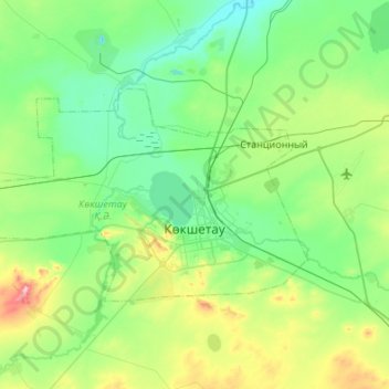
Nom : Carte topographique Kökchetaou, altitude, relief.
Lieu : Kökchetaou, Oblys d'Aqmola, Kazakhstan (53.22496 68.99717 53.40154 69.53819)
Altitude moyenne : 261 m
Altitude minimum : 199 m
Altitude maximum : 490 m
Autres cartes topographiques
Cliquez sur une carte pour visualiser sa topographie, son altitude et son relief.
Kökchetaou
Kazakhstan > Oblys d'Aqmola > Кокшетау Г.А. > Kökchetaou
Kökchetaou, Кокшетау Г.А., Oblys d'Aqmola, 020000, Kazakhstan
Altitude moyenne : 269 m
Зерендинский район - Зеренді ауданы
Зерендинский район - Зеренді ауданы, Oblys d'Aqmola, Kazakhstan
Altitude moyenne : 335 m