
Carte topographique Missoula
Carte interactive
Cliquez sur la carte pour afficher l’altitude.
À propos de cette carte
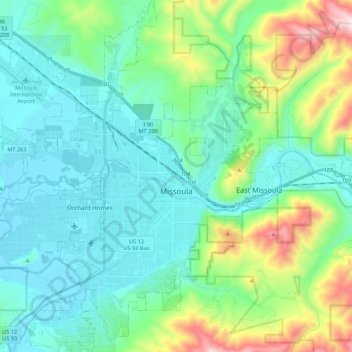
Nom : Carte topographique Missoula, altitude, relief.
Lieu : Missoula, Missoula County, Montana, United States (46.79154 -114.12729 46.94995 -113.89732)
Altitude moyenne : 1’173 m
Altitude minimum : 943 m
Altitude maximum : 2’021 m
Missoula is located at the western edge of Montana, approximately 45 miles (70 km) from the Idaho border. The city is at an elevation of 3,209 feet (978 m) above sea level, with nearby Mount Sentinel and Mount Jumbo steeply rising to 5,158 feet (1,572 m) and 4,768 feet (1,453 m), respectively. According to the Census Bureau's 2015 figures, the city had a total area of 29.08 square miles (75.3 km2), of which 28.90 square miles (74.9 km2) were land and 0.184 square miles (0.48 km2) were covered by water.
Autres cartes topographiques
Cliquez sur une carte pour visualiser sa topographie, son altitude et son relief.
Frenchtown
United States > Montana > Missoula County > Frenchtown
Frenchtown, Missoula County, Montana, United States
Altitude moyenne : 1’019 m
Seeley Lake
United States > Montana > Missoula County
Seeley Lake, Missoula County, Montana, United States
Altitude moyenne : 1’348 m
Missoula
United States > Montana > Missoula County > Missoula
Missoula, Missoula County, Montana, 59807, United States
Altitude moyenne : 1’354 m
De Smet
United States > Montana > Missoula County
De Smet, Missoula County, Montana, 59808, United States
Altitude moyenne : 996 m
Condon
United States > Montana > Missoula County
Condon, Missoula County, Montana, 59826, United States
Altitude moyenne : 1’146 m
Seeley Lake
United States > Montana > Missoula County
Seeley Lake, Missoula County, Montana, 59868, United States
Altitude moyenne : 1’250 m
Clinton
United States > Montana > Missoula County
Clinton, Missoula County, Montana, United States
Altitude moyenne : 1’180 m
Lolo
United States > Montana > Missoula County > Lolo
Lolo, Missoula County, Montana, United States
Altitude moyenne : 1’077 m
Clearwater Lake
United States > Montana > Missoula County
Clearwater Lake, Missoula County, Montana, United States
Altitude moyenne : 1’491 m
Lolo Hot Springs
United States > Montana > Missoula County > Lolo Hot Springs
Lolo Hot Springs, Missoula County, Montana, United States
Altitude moyenne : 1’377 m
Huston
United States > Montana > Missoula County
Huston, Missoula County, Montana, United States
Altitude moyenne : 2’321 m