
Carte topographique Rothmühle
Carte interactive
Cliquez sur la carte pour afficher l’altitude.
À propos de cette carte
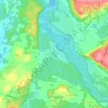
Nom : Carte topographique Rothmühle, altitude, relief.
Altitude moyenne : 635 m
Altitude minimum : 600 m
Altitude maximum : 712 m
Autres cartes topographiques
Cliquez sur une carte pour visualiser sa topographie, son altitude et son relief.
Grafing
Deutschland > Bayern > Landkreis Bad Tölz-Wolfratshausen > Königsdorf
Grafing, Königsdorf, Landkreis Bad Tölz-Wolfratshausen, Bayern, 82549, Deutschland
Altitude moyenne : 633 m