
Carte topographique Colorado Plateau
Carte interactive
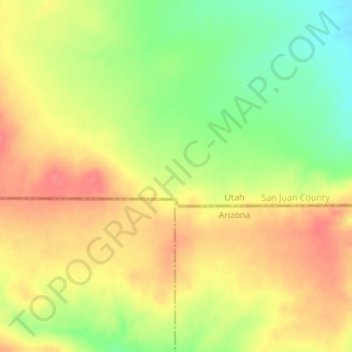
Cliquez sur la carte pour afficher l’altitude.
À propos de cette carte
Nom : Carte topographique Colorado Plateau, altitude, relief.
Altitude moyenne : 1’512 m
Altitude minimum : 1’474 m
Altitude maximum : 1’540 m
Younger igneous rocks form spectacular topographic features. The Henry Mountains, La Sal Range, and Abajo Mountains, ranges that dominate many views in southeastern Utah, are formed about igneous rocks that were intruded in the interval from 20 to 31 million years: some igneous intrusions in these mountains form laccoliths, a form of intrusion recognized by Grove Karl Gilbert during his studies of the Henry Mountains. Ship Rock (also called Shiprock), in northwestern New Mexico, and Church Rock and Agathla, near Monument Valley, are erosional remnants of potassium-rich igneous rocks and associated breccias of the Navajo Volcanic Field, produced about 25 million years ago. The Hopi Buttes in northeastern Arizona are held up by resistant sheets of sodic volcanic rocks, extruded about 7 million years ago. More recent igneous rocks are concentrated nearer the margins of the Colorado Plateau. The San Francisco Peaks near Flagstaff, south of the Grand Canyon, are volcanic landforms produced by igneous activity that began in that area about 6 million years ago and continued until 1064 C.E., when basalt erupted in Sunset Crater National Monument. Mount Taylor, near Grants, New Mexico, is a volcanic structure with a history similar to that of the San Francisco Peaks: a basalt flow closer to Grants was extruded only about 3000 years ago (see El Malpais National Monument). These young igneous rocks may record processes in the Earth's mantle that are eating away at deep margins of the relatively stable block of the Plateau.
Autres cartes topographiques
Cliquez sur une carte pour visualiser sa topographie, son altitude et son relief.
Allen Canyon
United States > Utah > San Juan County
Allen Canyon, San Juan County, Utah, United States
Altitude moyenne : 1’950 m
Lake Powell
United States > Utah > San Juan County
Lake Powell, San Juan County, Utah, United States
Altitude moyenne : 1’555 m
White Canyon
United States > Utah > San Juan County
White Canyon, San Juan County, Utah, United States
Altitude moyenne : 1’841 m
Beef Basin Wash
United States > Utah > San Juan County
Beef Basin Wash, San Juan County, Utah, United States
Altitude moyenne : 2’088 m
Spanish Valley
United States > Utah > San Juan County
Spanish Valley, San Juan County, Utah, United States
Altitude moyenne : 1’708 m
Monticello
United States > Utah > San Juan County
Monticello, San Juan County, Utah, United States
Altitude moyenne : 2’145 m
Rainbow Bridge National Monument
United States > Utah > San Juan County
Rainbow Bridge National Monument, San Juan County, Utah, United States
Altitude moyenne : 1’288 m
Hovenweep National Monument
United States > Utah > San Juan County
Hovenweep National Monument, Shiprock Agency, San Juan County, Utah, United States
Altitude moyenne : 1’632 m
Red Canyon
United States > Utah > San Juan County
Red Canyon, San Juan County, Utah, United States
Altitude moyenne : 1’479 m
Abajo Mountains
United States > Utah > San Juan County
Abajo Mountains, San Juan County, Utah, United States
Altitude moyenne : 2’874 m
Island in the Sky
United States > Utah > San Juan County
Island in the Sky, San Juan County, Utah, United States
Altitude moyenne : 1’804 m
Mexican Hat
United States > Utah > San Juan County
Mexican Hat, San Juan County, Utah, United States
Altitude moyenne : 1’346 m
Kane Gulch
United States > Utah > San Juan County
Kane Gulch, San Juan County, Utah, United States
Altitude moyenne : 1’975 m
Blanding
United States > Utah > San Juan County
Blanding, San Juan County, Utah, 84511, United States
Altitude moyenne : 1’851 m
Fish Creek Canyon Wilderness Study Area
United States > Utah > San Juan County
Fish Creek Canyon Wilderness Study Area, San Juan County, Utah, United States
Altitude moyenne : 1’817 m
Bullet Canyon
United States > Utah > San Juan County
Bullet Canyon, San Juan County, Utah, United States
Altitude moyenne : 1’893 m
La Sal
United States > Utah > San Juan County
La Sal, San Juan County, Utah, 84530, United States
Altitude moyenne : 2’098 m
Bluff
United States > Utah > San Juan County > Bluff
Bluff, San Juan County, Utah, 84512, United States
Altitude moyenne : 1’424 m
Oljato-Monument Valley
United States > Utah > San Juan County
Oljato-Monument Valley, San Juan County, Utah, 84536, United States
Altitude moyenne : 1’557 m
Upheaval Dome
United States > Utah > San Juan County
Upheaval Dome, San Juan County, Utah, United States
Altitude moyenne : 1’627 m
Stagecoach
United States > Utah > San Juan County
Stagecoach, San Juan County, Utah, United States
Altitude moyenne : 1’690 m