
Carte topographique Zarakes
Carte interactive
Cliquez sur la carte pour afficher l’altitude.
À propos de cette carte
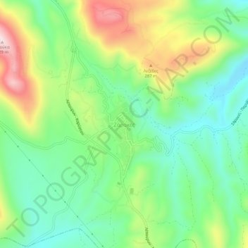
Nom : Carte topographique Zarakes, altitude, relief.
Altitude moyenne : 154 m
Altitude minimum : 10 m
Altitude maximum : 411 m
Autres cartes topographiques
Cliquez sur une carte pour visualiser sa topographie, son altitude et son relief.
Παλιούρια
Griechenland > Thessalien - Mittelgriechenland > Regionalbezirk Euböa
Παλιούρια, Δήμος Κύμης - Αλιβερίου, Regionalbezirk Euböa, Region Mittelgriechenland, Thessalien - Mittelgriechenland, Griechenland
Altitude moyenne : 116 m
Karystos
Griechenland > Thessalien - Mittelgriechenland > Regionalbezirk Euböa
Karystos, Δήμος Καρύστου, Regionalbezirk Euböa, Region Mittelgriechenland, Thessalien - Mittelgriechenland, 340 01, Griechenland
Altitude moyenne : 167 m