
Carte topographique Turnerville
Carte interactive
Cliquez sur la carte pour afficher l’altitude.
À propos de cette carte
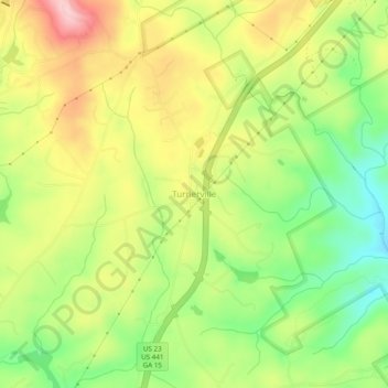
Nom : Carte topographique Turnerville, altitude, relief.
Lieu : Turnerville, Habersham County, Georgia, 30580, United States (34.66676 -83.44600 34.70676 -83.40600)
Altitude moyenne : 463 m
Altitude minimum : 371 m
Altitude maximum : 564 m
Autres cartes topographiques
Cliquez sur une carte pour visualiser sa topographie, son altitude et son relief.
Tugaloo
United States > Georgia > Habersham County > Tallulah Falls
Tugaloo, Tallulah Falls, Habersham County, Georgia, United States
Altitude moyenne : 392 m
Habersham
United States > Georgia > Habersham County
Habersham, Habersham County, Georgia, 30544, United States
Altitude moyenne : 409 m
Baldwin
United States > Georgia > Habersham County
Baldwin, Habersham County, Georgia, United States
Altitude moyenne : 395 m
Clarkesville
United States > Georgia > Habersham County
Clarkesville, Habersham County, Georgia, United States
Altitude moyenne : 418 m
Mount Airy
United States > Georgia > Habersham County
Mount Airy, Habersham County, Georgia, United States
Altitude moyenne : 443 m
Demorest
United States > Georgia > Habersham County
Demorest, Habersham County, Georgia, United States
Altitude moyenne : 416 m
Apple Pie Mountain
United States > Georgia > Habersham County
Apple Pie Mountain, Habersham County, Georgia, 30573, United States
Altitude moyenne : 537 m
Cornelia
United States > Georgia > Habersham County
Cornelia, Habersham County, Georgia, United States
Altitude moyenne : 446 m
Tallulah Falls
United States > Georgia > Habersham County
Tallulah Falls, Habersham County, Georgia, United States
Altitude moyenne : 488 m