
Carte topographique Reichelsheim (Odenwald)
Carte interactive
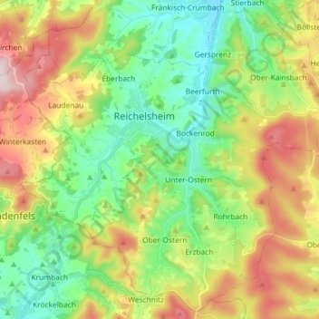
Cliquez sur la carte pour afficher l’altitude.
À propos de cette carte
Nom : Carte topographique Reichelsheim (Odenwald), altitude, relief.
Lieu : Reichelsheim (Odenwald), Odenwaldkreis, Hesse, 64385, Germany (49.65582 8.78444 49.74506 8.92912)
Altitude moyenne : 335 m
Altitude minimum : 179 m
Altitude maximum : 595 m
Reichelsheim lies in the middle Odenwald at elevations between 200 and 538 m in the middle of the Geo-Naturpark Bergstraße-Odenwald.