
Carte topographique Chaharmahal and Bakhtiyari Province
Carte interactive
Cliquez sur la carte pour afficher l’altitude.
À propos de cette carte
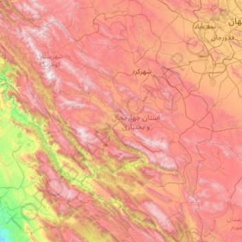
Nom : Carte topographique Chaharmahal and Bakhtiyari Province, altitude, relief.
Lieu : Chaharmahal and Bakhtiyari Province, Iran (31.14987 49.50008 32.80907 51.43433)
Altitude moyenne : 2’064 m
Altitude minimum : 215 m
Altitude maximum : 4’153 m
Autres cartes topographiques
Cliquez sur une carte pour visualiser sa topographie, son altitude et son relief.
دهستان حومه شهرکرد
Iran > Chaharmahal and Bakhtiyari Province > Sharekurd County
دهستان حومه شهرکرد, بخش مرکزی, Sharekurd County, Chaharmahal and Bakhtiyari Province, Iran
Altitude moyenne : 2’229 m
دهستان بازفت بالا
Iran > Chaharmahal and Bakhtiyari Province > Kuhrang County
دهستان بازفت بالا, بخش بازفت, Kuhrang County, Chaharmahal and Bakhtiyari Province, Iran
Altitude moyenne : 2’250 m
Bazoft
Iran > Chaharmahal and Bakhtiyari Province > Kuhrang County
Bazoft, بخش بازفت, Kuhrang County, Chaharmahal and Bakhtiyari Province, 88691-80537, Iran
Altitude moyenne : 1’569 m
Farrokhshahr
Iran > Chaharmahal and Bakhtiyari Province > Sharekurd County
Farrokhshahr, بخش فرخ شهر, Sharekurd County, Chaharmahal and Bakhtiyari Province, Iran
Altitude moyenne : 2’154 m
Sar Khun, Chaharmahal and Bakhtiari
Iran > Chaharmahal and Bakhtiyari Province > Ardal County
Sar Khun, Chaharmahal and Bakhtiari, بخش میانکوه, Ardal County, Chaharmahal and Bakhtiyari Province, Iran
Altitude moyenne : 1’622 m
Saman
Iran > Chaharmahal and Bakhtiyari Province > Saman County > Saman
Saman, بخش مرکزی, Saman County, Chaharmahal and Bakhtiyari Province, Iran
Altitude moyenne : 1’997 m
Shahr-e Kord
Iran > Chaharmahal and Bakhtiyari Province > Shahr-e Kord
Shahr-e Kord, بخش مرکزی, Sharekurd County, Chaharmahal and Bakhtiyari Province, Iran
Altitude moyenne : 2’210 m
Shahr-e Kord
Iran > Chaharmahal and Bakhtiyari Province > Sharekurd County
Shahr-e Kord, بخش مرکزی, Sharekurd County, Chaharmahal and Bakhtiyari Province, Iran
Altitude moyenne : 2’102 m