
Faire un don
Équipez-vous pour votre prochaine aventure :
En tant que Partenaire Amazon, ce site perçoit une commission sur les achats éligibles sans surcoût pour vous.
Carte topographique 06636
Cliquez sur la carte pour afficher l’altitude.
Faire un don
Équipez-vous pour votre prochaine aventure :
En tant que Partenaire Amazon, ce site perçoit une commission sur les achats éligibles sans surcoût pour vous.
À propos de cette carte
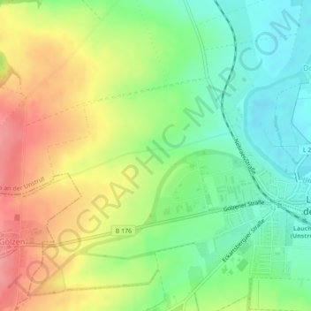
Nom : Carte topographique 06636, altitude, relief.
Altitude moyenne : 146 m
Altitude minimum : 105 m
Altitude maximum : 198 m
Faire un don
Équipez-vous pour votre prochaine aventure :
En tant que Partenaire Amazon, ce site perçoit une commission sur les achats éligibles sans surcoût pour vous.
Autres cartes topographiques
Cliquez sur une carte pour visualiser sa topographie, son altitude et son relief.
Dorndorf
Deutschland > Sachsen-Anhalt > Burgenlandkreis > Laucha an der Unstrut
Dorndorf ist vermutlich eine fränkische Neugründung aus dem 8. Jahrhundert. Das Dorf wurde 1271 erstmals urkundlich erwähnt. Der erste Ort Dorndorf soll sich auf der Anhöhe, oberhalb der Straße Dorndorf-Gleina befunden haben. Die Lehnshoheit im Ort und an den Gütern darinnen, besaßen die Markgrafen von…
Altitude moyenne : 150 m